Pages

Friday, April 29, 2011

Pipe Band Caught Near Tornados

A 25-strong group from Bideford Youth Pipe Band also had first-hand experience of the natural disaster which hit North Carolina.


 See: http://hatgensoc.wordpress.com/2011/04/15/the-british-invasion-on-hatteras/

They were performing in Bideford’s twin town of Manteo when the tornadoes struck the region.
Although not directly affected, it was a scary time as the 17 youngsters and eight adults listened to the tornado sirens and watched news flashes on television tracing the paths of the ‘twisters’ on the screen.
At one point they were told to take shelter in the central corridor of the housing complex where they were staying and given cushions to hold over their heads, said band secretary Mike Harper.

cont. here:
http://www.northdevongazette.co.uk/news/pipe_band_among_the_twisters_1_877174.

This blog is © History Chasers
Click here to view all recent Lost Colony Research Group Blog posts
Bookmark and Share

Thursday, April 28, 2011

Andy's Tornado Terror

Andy was returning from his third visit to North Carolina, where he has been taking part in archaeological digs in his bid to find evidence of the first British settlements and prove the part played by people from Bideford in the founding of America.
All his visits have been strangely dogged by natural disasters, but this one ended in terror. “I really feel that this time I cheated death,” he said.
After two weeks of successful digs with Professor Mark Horton and students from Bristol University, Andy stayed behind an extra day to visit Bideford’s twin town of Manteo, where the Bideford Youth Pipe Band was performing.
Over the weekend the tornadoes struck.
“I was told they usually have around 20 tornadoes during April, but in two days they had 62,” he said.
“Three people died within a mile of the local airport from where my journey home began. We set off in a twin turbo-prop plane with 58 passengers. The 35 minute flight to the main Newark Airport for the flight home took us two hours. We flew straight into the storm over Newark. We were told to strap ourselves in and hold on to everything that was dear. Our descent was at a 45 degree angle as we tried to get down and beat the storm. There was zero visibility, lighting was flashing and 70mph cross-winds were reported. My 16 stone frame was lifted from the seat, despite being strapped in.
Cont. here:

This blog is © History Chasers
Click here to view all recent Lost Colony Research Group Blog posts
Bookmark and Share

Wednesday, April 20, 2011

Archaeology – 99.9% Dig, Sweat, Move Dirt

by Roberta Estes
 
Archaeology is so tangible.  Everyone wants to dig in the dirt and find treasure.   Indiana Jones watch out!
 
Today we took a break to come back and find a 9 year old boy happily digging in the bottom of one of our archaeology pits.  Not exactly the kind of “find” we wanted.  And yes, that tends to “ruin the pit”.
 
But for the most part, archaeology, for those doing the digging, is 99.9% dig, sweat and move dirt from place to place.  More precisely, you dig it out of one place, sift it with a screen sifter to be sure you have even the smallest artifacts, and then when the pile under the screen sifter gets too large, you either move the pile or the sifter, one or the other and start a new pile.  Eventually, when you’re done digging in that location, meaning you’re reached a “sterile” layer, you then get to backfill all of the dirt that you just dug out and sifted.
 
Many locations, known in the vernacular, as “pits”, produce nothing of note.  Here, we have lots of oyster shells, and I mean LOTS of shells.  In some of the earliest deeds this general location was called “Oyster Shell Banks” for a reason.  There are lots of other kinds of shells too.  One thing is for sure, the native people didn’t starve here, nor did the early settlers.  If you could fish or gather shellfish, you could survive. 
 
Other locations produce interesting things, but just not exactly what you are looking for.  Can anyone guess what the “find” below is?  It’s actually quite attractive with its design on the front.  If you can’t guess, I’ll tell at the end of this posting.

 
Many things that people threw away 100 or 200 or more years later, we find fascinating.  Trash piles, known as middens, are the archaeologist’s mainstay.  Find the midden and you can tell heaps, pardon the pun, about the people who lived there.  Think about our current middens, known as landfills.  People would think we worship an entity that looks like Ronald McDonald based on all of the fast food wrappers in the trash.
 
The area where we’ve been digging apparently served as a trash heap for some number of years, and apparently, off and on for centuries.  It’s in a rather high area very close to a sheltered channel that leads to the sea.  This would be a wonderful area for a fisherman to pull his boat in and unload his catch and clean it safely out of the wind and sun. 
 
In fact, can you see the artifact below in the photo?


If you can’t see it in the photo above, maybe the one below from the other direction will be easier.


This boat isn’t “old”, but it is in the process of being reclaimed by the earth.  One good storm with blowing dunes and this boat will be covered, waiting for the next group of archaeologist in another 100 or 200 years.
 
Oh yes, before I forget to tell you, the mystery artifact is a part of an old stove.

This blog is © History Chasers
Click here to view all recent Lost Colony Research Group Blog posts
Bookmark and Share

Tuesday, April 19, 2011

Tornado

4-16-2011

Just when we thought we had escaped the 2011 dig with no catastrophes, a tornado struck.  Fortunately, it only delayed Andy's flight by 5 or 6 hours, not 5 or 6 days like the previous events.  About this same time, I had left Beckley, West Virginia, (yes, Beckley again) and was driving near Charleston, down a hill, in construction, when I rounded a curve and wondered if the white "wall" ahead was fog.  Within seconds, I realized it was not fog, it was driving sheets of rain and hail.  I noticed a sign about this time stating an exit was about 2 miles away.  That last two miles, driving down a mountain in rain so hard that you could see nothing, not the lines on either side of the road, nothing at all...was terrifying.  Extremely harrowing - making me wonder at what point I would see my life pass before me. 

I was afraid to pull off in a construction zone because I didn't know if there was a shoulder.  I decided I had to stop, regardless, because I was going to hit something otherwise, although I was terrified that someone would hit me.  I knew someone, especially a truck, coming down that mountain wouldn't see my flashers until it was too late. 
I pulled over, just in time to see the green sign right beside me with an arrow pointing to the exit ramp.  I've never been so grateful for an exit ramp.  I crept down the ramp to the single filling station and discovered they had no power.  Do you know how difficult it is to visit the bathroom in total darkness?  

I knew George was taking Andy Powell to the airport and I had to wonder how they were being affected.  The storm was brutal and short, followed by flash floods.  Later, I would discover that a tornado struck very near George's home, where George and Andy had spent the night before George took Andy to the airport.  Andy was actually at the airport, and his flight did leave, even if significantly delayed by several hours.  So now, we've had our digs ushered out by a hurricane, a volcanic eruption and a tornado.  What's next? 

This blog is © History Chasers
Click here to view all recent Lost Colony Research Group Blog posts
Bookmark and Share

Crowned on Hatteras Island


You just never know what’s going to happen.  When I travel, I make the local library a mandatory stop – and they are always a wonderful resource.  But never, ever, have I been crowned a Princess in a library before.  In fact, I’ve never been a princess anyplace.  But everyone should be a princess at least once in their life, even if for a fleeting 15 minutes or so.
 
So how was I crowned Princess?  It has to do with a non-cooperative printer and beating said printer into submission.  They brought be the “brainiac tierra” and I wore it around, forgetting about it.  Some time later, I went to make copies and realized that the entire line of people waiting at the service counter were looking strangely at me.  I kind of thought that was odd….but didn’t think any more about it until I went to the restroom and realized that I still was wearing by special tierra. 
 
Anne snapped a photo for posterity.  I did my good deed for the day, and we were off to find our Lost Colonists!


Monday, April 18, 2011


April 14, 2011...was a special day for Manteo, NC., and it's twinned sister city... Bideford, England. Andy Powell, retired Mayor of Bideford and the Bideford Youth Pipe Band, graced the streets of Manteo with a visit from across the pond.

Andy, who was already on the Outer Banks to once again participate in an archaeology dig, shared this special occasion with two other LCRG members, Dawn Taylor and George Ray. They accompanied him for an hour long ride "up the beach", to hear a very talented group of young musicians, who ranged from ten to eighteen years of age, share a bit of England with locals and visitors alike.

The Bideford Youth Pipe Band, honored the retirement of Andrew Thomas Powell, by serenading him with the song, Auld Lang Syne. A song among several that echoed down Budleigh Street and onto the Manteo waterfront, where onlookers, including an English wedding party, listened as bagpipes were played and the beat of the drums, filled the air.


This blog is © History Chasers
Click here to view all recent Lost Colony Research Group Blog posts
Bookmark and Share

Ghosthunt


Tonight was a very unique experience.  Every dig has to have lighthearted moments.  This one is no exception, and tonight we had a wonderfully fun adventure.
 
We went on a ghosthunt with a ghosthunter.  I can’t tell you exactly where, but suffice it to say that it is a historic building with a history of high drama involving life and death.  


Our ghosthunter provided various types of sensor equipment, some that detected motion with a laser beam, some that detected electromagnetic signals, some that detected audio and cameras.  We had a significant amount of technical issues with the electrical equipment, which the hunter said was not unusual if there are ghosts present.
 
We spend a couple of hours at the site, doing various things, taking measurements and photos, and the outcome was that perhaps there are ghosts resident there. 
 
They have been reported in the past.  Lights on in an unoccupied building and “people” sighted looking out of the windows in the top level of the building.  This building has been entirely unoccupied, abandoned, for some time. 
 
Regardless of whether there are ghosts who live there or not, it was a fun evening on Hatteras Island for our merry band of Lost Colony seekers, Angel Roller, Anne Poole, Dawn Taylor and Nancy Frey.


This blog is © History Chasers
Click here to view all recent Lost Colony Research Group Blog posts
Bookmark and Share

Friday, April 15, 2011

Beating a Dead Horse


  You’ve all heard this phrase.  We have a bit of a different twist to this.  Ours is washing a dead horse….and yes….literally.  You never know what you’re going to find when you’re doing an archaeology dig. 
 
We were fortunate enough to discover an old homesite trash pile.  I’m not sure at what point in history you stop calling it a midden and start calling it a trash pile.  Regardless, this trash pile was from a pioneer homesite and we are calling it a midden. This midden was a literal goldmine producing a wide variety of artifacts as the family who lived there in the 1700s threw things away.  


All middens contains examples of the local wildlife.  In our case, we have found thousands of seashells, bird bones, turtle bones and deer.  Many small bones are unidentifiable individually.  However, we found a real surprise.
 
We found a horse skeleton.  I’ve come to the conclusion that horses are huge animals.  I know that seems evident, but cleaning all of these bones demonstrated graphically just how huge those animals actually are. 


The horse skeleton was in the middle of the trash pile.  It had all probably been buried at one time, but it was not what we call “in situ”, meaning that the bones were “as buried”, so the bones likely got shuffled around in the trash pile or midden as other things got added and storms passed through.  Remember, the sands here shift.
 
But the horse skeleton is now part of the archaeological record of this homestead, so the pieces came out along with the broken pottery and other items telling the story of this pioneer family.


Unlike with humans, this horse has no tombstone, but you know he or she had a name and the family loved their horse.  Horses were part of the family, a contributing member, and everyone was sad when the horse passed away.  This horse was not relegated to total anonymity however, as he or she is now again living as part of the archaeology of Hatteras Island.


This blog is © History Chasers
Click here to view all recent Lost Colony Research Group Blog posts
Bookmark and Share

Thursday, April 14, 2011

Processing Artifacts

 by Roberta Estes


Most people think of an archaeological dig as the actual digging.  That’s the Indiana-Jones-esque exciting part.  After that, most people don’t think much about what happens – but in reality, that is only the beginning of the process.
 
I’d like to take you along with me on a typical day of processing artifacts – and of course along the way, you’ll be able to see some of what was found during this dig.
 
At the dig site, when something is found either directly by digging or in the sifting process, it is put in a specimen bag and labeled as to the trench number, the level and sometimes other pertinent information. 
 
At the end of the day, those bags, and you hope there ARE bags, are taken back to the headquarters, wherever that may be, do be processed.  In our case, you saw in earlier blogs that we had rented a house and the processing takes place there.  Fortunately, they have a nice deck out back, so we can use the deck in the washing and drying phase of artifact processing.
 

Generally, the bags are full of artifacts and a lot of dirt.  They often just look like mud pies.  Back at the house, we remove the artifacts and try to determine whether they are metal, shell, bone or pottery.  Different artifacts are processed differently.

Old shell sometimes disintegrates in water, so the shell has to be evaluated as to it’s condition before processing.
 
Bone can be fairly stable, or very crumbly. It too had to be evaluated.  Generally, when we can, we wash bone very gently and use a toothbrush to clean any crevices.  Pottery and glass are very washable.  Iron can’t be immersed in water, so it is dry brushed.  Below, Alex, one of our lovely students (in the orange shirt) is dry brushing an iron lock and I’m cleaning a piece of a hand blown wine bottle.


Another piece of the wine bottle is shown below.  Notice the very uneven rim.  Can’t you just see this touching Blackbeard’s lips?
 
 
When we dump the contents of the bag out, it is generally a muddy mess.  This pile is actually relatively clean.  In some cases, you can barely tell there is anything except dirt, mud and sand.

After the artifacts are cleaned with water and a soft brush, we place them in drying trays on newspaper along with their artifact bag to dry outside in the sun on the porch. 
 

  After they dry, they are brought back in to the processing table where they are identified, dated, if possible, logged as to how many, the size of the artifact, where it was found and sometimes they are drawn or photographed, or both.

  
In the photo above, Dr. Mark Horton is seated in the center identifying the objects.  Two students are working with him.  The student to the left is logging the items into a log book.  This log book plus measurements, photographs and other data will be combined into a report that fully documents the dig, called a field report.  Of course, after the team returns to Bristol, they will be studying the data to more fully understand this homestead we have found.


Editor's note: click on the images twice to open them up to their full size. 

This blog is © History Chasers
Click here to view all recent Lost Colony Research Group Blog posts
Bookmark and Share

Hatteras Island Genealogical and Preservation Society (HIGS)

by Roberta Estes

 
On Tuesday evening, Andy Powell and I were honored to speak at the Hatteras Island Genealogical and Preservation Society in Avon.  The evening began with a lovely pot luck carry in provided by the members of the society.  The main courses were provided by HIGS and the Lost Colony Research Group.  Side dishes were brought by attendees.  These meals are always the best.
 
Someone brought a wonderful Hatteras Island clam chowder, an island specialty.  W what a treat!  There is just nothing like local specialties.  I can envision this same clam chowder nourishing the ancestors of these folks, who may indeed have been the Lost Colonists.
 
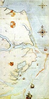
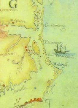
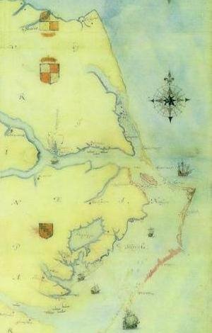
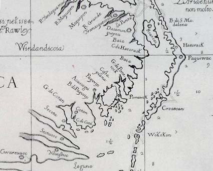
Anne Poole, Research Director for the Lost Colonists began the evening with a brief introduction and then the first speaker, yours truly, spoke about the Lost Colony, the DNA project, the Hatteras Families projects, and the historical and genealogical projects we’ve undertaken in an effort to find the colonists.  Given what the colonists themselves told us about where they were going, it seems that Hatteras Island is the best place to look for them, and where we are most likely to find them.  I couldn’t help but wonder if I wasn’t looking at the colonists’ descendants as I was speaking about the project.
 
Anne Poole then spoke again about the various surnames involved with the Lost Colony and her efforts to work with the families who carry those surnames in eastern NC.
 
Andy Powell, the retiring mayor of Bideford, England, the port from whence the colonists sailed, and possibly the home of some of them, spoke next.  Andy’s book, Sir Richard Grenville and the Lost Colony of Roanoke was recently released.  In fact, so recently, that Andy wasn’t sure he could even get books here for the event.  Thankfully, he had a least a few to sign for people. 
 
Andy re-translated the original documents, and in his book, he then provides the original translation in addition to “understanding aids” for us.  To say there is a bit of a language barrier would be an understatement, but his translations from early English to contemporary English make the difference between slogging through a book and a ‘good read’.  This book is both fascinating in its history, but also simply as a good book.  Few books achieve both.
 
 
Something I found even more remarkable is that Andy truly knows his topic inside and out and upside down.  He has all of these facts in his head.  He used no notes or Powerpoint, but talked directly about the history, including exact dates, as he wrote in his book.  Not only is he the most authoritative voice on Grenville worldwide, but he loves the topic of the Lost Colony mystery and history, and hopes that the interest in the Lost Colony will provide both the NC coastal communities as well as Bideford some rejuvenation to their economy. 
 
Indeed it may, as exchanges are already underway.  Later this week, the Bideford marching band will be performing in Manteo!  Bideford and Manteo are twinned, with the official ceremony taking place in 2010.
 
After the speakers, questions were taken from the audience and many people visited with the speakers as well as others from both groups.  Many who attended were members of HIGS, but Dawn Taylor, HIGS founder, mentioned that she saw several new faces. 
 
The LCRG and HIGS are collaborating to create the Hatteras Families genealogy data base, and several people used that resource to look up ancestors.  This data base is the underlying foundation of the Hatteras Families DNA projects.  Ultimately, Dawn hopes to add detail for each of the early island families.
 
Andy Powell, Anne Poole and I, in addition to our other LCRG members who were present, would like to thank Dawn Taylor and the rest of the HIGS folks who worked hard on preparations to have a lovely evening for their hospitality.

Wednesday, April 13, 2011

Spear Point

Editor's note: We will continue to publish article's from the Hatteras Dig as they become available.

by Roberta Estes

Archaeology is a surprise every day.  Some day the surprise is that you find nothing.  We call those “sterile pits”, and indeed, they are the pits.  Very disappointing.  See my blog about how archaeology is 99.9% dig, sweat and move dirt.
 
But the, poking it’s head out of the dirt is the entire reason you’re digging.  An artifact reveals itself.  Someone lets out a little yelp, or maybe a big yelp, and everyone comes running to see – no matter what it is.  Yelp = hurry up and look = something is happening and you’re going to get a break from digging!

 
Today, the gift from the earth and the ancestors is a spear point – a stunningly beautiful spear point.  Technically, it is from the Savannah River late archaic period.  What this means in more people friendly terms is that it’s about 3500 years old.  Think of that, 1500 years before the birth of Christ – a native person was chipping away at this spear point in order to find supper.  It bring us closer to him in a timeless sort of way.


This spear point was well used.  It’s entirely possible that it was used literally for many generations, passed from person to person, until someone lost it in the midden where we found it.  So in actuality, even though we’re not using it to hunt for dinner, the life of this particular spear point is not over, just on another chapter of its journey, in part, to help educate us about what the local people were doing, where, and how.


This blog is © History Chasers
Click here to view all recent Lost Colony Research Group Blog posts
Bookmark and Share

Jasmine, Sweet Jasmine

by Roberta Estes

One thing I love about new places is their flora and fauna, especially when it’s blooming.  Yesterday, while walking near a dig pit, I noticed several yellow flowers on the ground.  This was in a forested area.  There were no yellow flowers nearby, so I looked around and finally, up, to find a canopy of Jasmine overhead.
 
Its sweet smell was also wafting through the forest, an unexpected delight.  In Michigan, we don’t have climbing flowering vines, except for trumpet vine, so Jasmine was something I had never experienced before.  Jasmine climbs to the top of the highest trees and then flowers at the very top in the sun.  This makes it rather difficult to photograph.  However, I found a tree with a decent “view” to the top, as this area is rather canopied, and took a few photos that I’d love to share with you.


Editor's note:
These photos can be viewed at high resolution by clicking on the image, then clicking again on the resultant image. Enjoy!

This blog is © History Chasers
Click here to view all recent Lost Colony Research Group Blog posts
Bookmark and Share

Tuesday, April 12, 2011

"Sock it to Me" Birthday Cake

by Roberta Estes
Archaeology Birthday Party
 
What kind of a birthday cake do you make for someone who loves archaeology?  A special archaeology birthday cake of course!!
 
 
We celebrated Andy’s birthday on Sunday and Maggie Dawson made an incredible cake for Andy, complete with the pit, of course, and the sifter where we sift the dirt for artifacts.  Within our digging group, Andy is well known for his “discovery” of a sock on our first dig.  Of course, we couldn’t tell that it was a sock and we thought perhaps it was an early textile.  It was mudsoaked, as it was extracted during a hurricane (Ida), and it wasn’t until it was cleaned and processed until we discovered it was in actuality a contemporary item.  Andy, in the spirit of friendship, has never been allowed to live his wonderful “discovery” down, and on the cake, our archaeologist indeed has discovered a sock and pulled it out of his hole.


As we “excavated” the birthday cake, we discovered that the cake is stratified in layers, and indeed, in the bottom “dirt” layer, we found artifacts.  Just like real archaeology, you had to go and clean your artifact to see what treasure you had found.


We had a great time at Andy’s party, as did Andy, but the cake itself indeed stole the day!!


This blog is © History Chasers
Click here to view all recent Lost Colony Research Group Blog posts
Bookmark and Share

Found - at last!!!!

by Roberta Estes
 
Aha – at last – we’ve found them!!  Right here on Hatteras Island, and right along Highway 12.  And we’ve solved how the colonists arrived as well….in a spaceship – and it’s still here- preserved and available for all to see.
 
Indeed, you never know what you’re going to find on Hatteras Island.  Imagine what the locals must have thought when this washed up on shore.


Here’s Anne checking it out.  She’s getting ready to go inside to see if the colonists are there!
  
If there’s a UFO in your yard, you should take advantage of it.


This blog is © History Chasers
Click here to view all recent Lost Colony Research Group Blog posts
Bookmark and Share

Monday, April 11, 2011

Struck by Lightening


 When reconstructing the Hatteras families from both genealogical and historic records, some truly remarkable historic tidbits are found.  Some of these aren’t really of any significance other than to the families involved and as sort of a general interest historic sort of way, but I find them fascinating regardless.  For example, did you know that lightening could strike you while you are in bed?
 
This  record is about the family of Washington W. Scarborough, born in 1862, son of Ezekiel Scarborough and his wife Catherine, thought to be a Barnes who initially married a Price.  Washington married Bethany Miller who was born between 1852 and 1854, the daughter of Hezekiah Claughton Miller and Bethania “Bethany” Gray.  They probably married in late 1872 or early 1873, judging from the birth of their first child, Dorcas Rosa Scarborough in December 1873, according to both family records and the census.  Their second child, Ezekiel Littleton Scarborough was born in December 1876.
 
The family history of both the Scarborough and the Miller families records their deaths.  Both Washington and his wife, Bethany, were killed, in bed, by lightening, while the small child who slept between them survived.  According to the Miller family records, Bethany died about 1885.  The Scarborough records don’t give a death date.  In the 1880 census, Cilioven, also known as Salome, was just 3 months old at the time the census was taken.  If they died shortly thereafter, she would have been the child between them.  There is no record of a later child being born to this couple. 
 
If they died in 1885, it’s unlikely that they had no children between 1880 and 1885.  Of course, if they had additional children, they could have died, and even a child who survived the initial lightening strike could have succumbed later to their injuries.  Dates in genealogical records that only provide a year are often “about” dates from someone’s later recollection and are often incorrect, so they could have died anytime between 1880 and 1885.
 
A sad tale indeed, but the kind of information important to genealogists.  Hatteras Island has the highest incidence of deaths from lightening strikes in the US. 


This blog is © History Chasers
Click here to view all recent Lost Colony Research Group Blog posts
Bookmark and Share

Sunday, April 10, 2011

HIGS and LCRG - Potluck Dinner and Lost Colony Adventure Tues. Night

 by Dawn Taylor 

Time
Tuesday, April 12 · 6:00pm - 9:00pm
 
 Location
Avon Firehouse, NC
 
 Created By
Hatteras Island Genealogical and Preservation Society
 
 
More Info
Hatteras Island Genealogy Society and the Lost Colony Genealogy and DNA
Research Group, are coming together to bring you some good eats and we will
have with us several guests, all specialists in aspects of Lost Colony
Research.
 
Roberta Estes, Director of the Lost Colony Research Group will give a
presentation about the ongoing research into the fate of the Lost Colony,
the Lost Colony DNA project, and the Hatteras Island Family ...project,
co-administered by Dawn Taylor. Dawn and Roberta will have their Hatteras
Island genealogy data base along for easy access this evening, so be sure to
see if your ancestor is listed. We'll be talking about what we've found in
the Hatteras families, genetically, too - so if it's results you're looking
for - you won't want to miss this.
 
Anne Poole, Research Director of the Lost Colony Research Group will be with
us as well.
 
Andy Powell, recently retired Mayor of Bideford England, and expert on the
English aspect of Lost Colony research will bring his recently released book
  Grenville and The Lost Colony of Roanoke, and will be sharing with us the
role of Sir Richard Grenville in the Lost Colony adventure. Andy has spent
years translating original English documents and will be sharing his
knowledge with us.
 
Prior to our special guest speakers, there will be a pot luck dinner.
HIGS and LCRG, will be supplying the main course and drinks. We do ask that
those attending, bring a side dish or dessert. The pot luck portion of the
night will be from 6-7 p.m. Our special guest speakers will start promptly
at 7 p.m
 
Hope to see you there !


This blog is © History Chasers
Click here to view all recent Lost Colony Research Group Blog posts
Bookmark and Share

Just When I Thought I had the Answer….Masque, Maskue, Askue, Massague, Massigay, Masagy, Maskie, Massechoes and Mashoes

by Roberta Estes
 
Enlightenment is where you find it..  In this case, it was laying on the steps.  I was visiting the home of Dawn Taylor and her lovely father, and I asked to use the restroom.  They directed me to the facility, which was up the stairs on the second level.  They do what we do at home, anything needing to go upstairs get stacked on the steps at the bottom and the next person to go up takes it along.  On their steps was an October 1996 edition of the Tyrrell Times, the publication of the Tyrrell County Genealogical Society.  I was immediately interested, and they loaned me the journal for a few days.  I found a very interesting article, which proved very enlightening relative to one of our Hatteras early families as well.
 
I thought I had this particular family figured out…..just when you think you have the answer, a left hook arrives.
 
In our Hatteras neighborhood project, we’ve been reconstructing the various neighborhoods from Buxton through Frisco in an effort to pinpoint the Native villages and to better understand the family relationships.  Through the joint efforts of several researchers over the past couple of years, we’ve succeeded in reconstructing these neighborhoods..  One of our mystery families, who don’t live on the Outer Banks anymore is the Joseph Maskue family.  Joseph is first found on Hatteras Island in 1757 when he receives a land grant of 300 acres “on Hatteras Banks” on the sound side near John Neals.  This was then Currituck County, later Hyde, and now Dare.
 
In 1767, George Masque sells the entire 300 acres patented by Joseph Masque to Benjamin Price, and the Masque (Maskie, Maskue) family disappears from the records of Hatteras Island. 
 
The reason this family was of particular interest is because the Maskue land abuts the land grand of William Elks, the Hatteras Indian family as reflected in the 1771 sale of part of the William Elks land.
 
I thought I had this family further identified.  A 1713 court record shows a Thomas Askue estate that involved Henry Davis, Patrick McKuen, John McKuen and Francis Farrow, all Hatteras men.  Henry Davis patented the land adjacent to the land that Joseph Maskue would patent in 1757.  The McKuen family were neighbors as well, and Francis Farrow, while not an adjacent neighbor, was an early island pioneer as well. 
 
 Admittedly, there is more than 40 years between the estate of Thomas Askue and the land grant of Joseph Masque, but the nearly exact location, the neighbors and the similarity of surnames is very certainly suggestive of a connection, especially considering that in 1713, there were very, very few families living on the Outer Banks, probably less than ten, judging from the early land grants and tax records.  Land grants on Hatteras really didn’t begin until after the Tuscarora War was resolved and it ended in 1713.
 
In the Tyrrell Times, James L. Liverman, wrote an article about a pair of French brothers who settled in Albemarle County at the end of the 17th century.  Unfortunately, he didn’t give specific dates, but I’ve extracted some of what he did say.
 
“A pair of Frenchmen came to live along the southern shore of the Albemarle Sound somewhere toward the end of the 17th century.  Probably Huguenots strayed from one of the colonies to the south.  Stephen was 25 at his first mention in the colonial records and seems to have located permanently just across the estuary from the Sand Banks in a neighborhood later to become a part of Tyrrell County, then to be lost to Dare, while the apparently more ambitious Benjamin made a claim “about 4 or 5 miles below Scuppernong River”.  This family name was variously rendered as Massague, Massigay, Masagy and other misadventures.  One clerk wrote it as Massechoes coming pretty close to the place names of Mashoes Creek and Mashoes in today’s mainland Dare County.
 
Legend has it that a shipwrecked Frenchman came ashore near present time Manns Harbor when that area was still completely uninhabited.  With his wife and family lost at sea, the marooned man is said to have carved the entire account of his travail onto a cedar shingle before he died of abandonment and grief.
 
Benjamin yclept (sic) Massenque abandoned his homestead below the Scuppernong probably at the same time he married one of the two orphaned daughters of Thomas Waller.  He then embarked on a series of lawsuits against a prominent citizen of the Albemarle by which he eventually secured custody of the other orphaned daughter and the Waller estate entire.  He was dead within the year. 
 
There is nothing in the surviving records about an heir, but a Peter Museos turns up in the court minutes 16 years after Benjamin’s death.  Then the name disappears from the archives, except for one trace that remains.  On the left hand side when headed out of Columbia south of NC94, you will notice in the vicinity of Ryder’s Creek the last memorial, a green placard sign that says “Pity My Shoe Road”.”
 
Liverman also spells the name Micheaux.
 
The first names don’t match.  We find Thomas Askue on Hatteras Island in 1713 and the Albemarle names were Benjamin and Peter.  The later Hatteras first names in the mid-1700s were Joseph and George.  However, the similarity between the surnames can’t be arbitrarily dismissed without further investigation.  I’d certainly appreciate any information that anyone has about these or similar surnames in this region of eastern North Carolina.


This blog is © History Chasers
Click here to view all recent Lost Colony Research Group Blog posts
Bookmark and Share