Lost Colony Research Group
July Newsletter
Genealogy-DNA-Archaeology
Following the Croatoan
In 2010 when the North Carolina Society of Historians awarded the Lost Colony Research Group the prestigious Malcolm Fowler Award, their question was why we weren't following the Croatoan. Little did they know, we are and have been for some time. Records that touch upon the Hatteras have been scattered throughout many different types of records in many locations. Altogether, there aren't many.
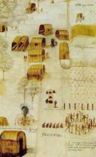
The Colonists left us one very clear message, in duplicate. When they left Fort Raleigh on Roanoke Island, they disassembled the houses and left in an orderly manner. In doing so, they also left two messages, "Cro" and "Croatoan", carved into a fort post and into a tree, in order to tell John White on his return trip where they would be found. They also left him another message, by omission. He had agreed with them that if they were in distress, they would carve a cross, the cross formee, along with any message, and there were no crosses. They were not in peril when they left. White tell us also that, prior to his departure in 1587, there had been discussion of plans to move "50 miles into the main", but his records are mute on any further location(s). The Chesapeake area has been speculated, but that doesn't match with the 50 mile criteria.
John White tells us in his journal in 1590 that he was greatly relieved that the colonists had joined their friends, the Croatoan, the tribe of Manteo, on Hatteras Island. And with that, they disappear from the English records. John White was blown back to England in a hurricane, never able to return. Subsequent expeditions were sporadic and had even less success in determining whether the colonists survived or not.
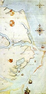
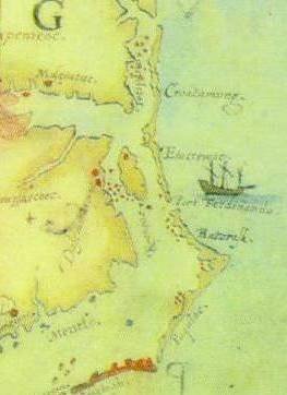
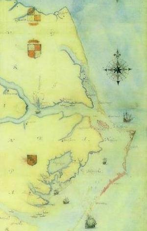
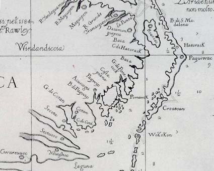
White and Harriot created a map in 1585 that showed in red the various locations of the Indian towns that were discovered during their explorations. The depiction of the Outer Banks was somewhat distorted, and of course the geography has changed between 1585 and 2010 as a result of various storms, but in essence, White showed the entire Island he called Croatoan as inhabited by Indians, as shown below. The outlet at the top of Croatoan is now closed so that Cape Hatteras today connects the two islands of Croatoan and Paquiwoc.

Cont. Here:
This blog is © History Chasers
Click here to view all recent Lost Colony Research Group Blog posts


