Greenville Daily Reflector
Today is the deadline to register for
the East Carolina University Lifelong Learning Program's The Lost Colony
and More Tour, scheduled for June 11-12 in Nags Head and Manteo. To register or
for more information, call 328-9198 or visit
http://www.ecu.edu/llp
This blog is © History Chasers
Click here to view all recent Lost Colony Research Group Blog posts
Tuesday, May 8, 2012
Register for the East Carolina University Lifelong Learning Program
Posted by
Historical Melungeons
at
5/08/2012 05:08:00 AM
![]()
Monday, May 7, 2012
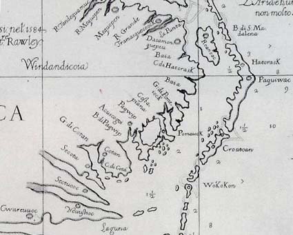
The Chowan Fort Discovery on the John White Map
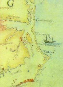
We can discuss logic and pros and cons today about whether the fort on the map was ever built, and for what purpose, but the real truth about the fort, if it ever existed in reality, lies someplace under about 1200 acres, including a golf course, near Salmon Creek in a location known as Avoca in present day Bertie Co., NC. We are excited about an upcoming archaeological dig being planned by the Lost Colony Foundation and look forward to their findings.
This blog is © History Chasers
Click here to view all recent Lost Colony Research Group Blog posts
Posted by
Historical Melungeons
at
5/07/2012 01:03:00 PM
![]()
Saturday, May 5, 2012
Map’s Hidden Marks Illuminate and Deepen Mystery of Lost Colony
This blog is © History Chasers
Click here to view all recent Lost Colony Research Group Blog posts
Posted by
Historical Melungeons
at
5/05/2012 01:13:00 PM
![]()
A New World: England's First View of America
http://www.amazon.com/gp/product/B005MWRU4K/ref=as_li_ss_tl?ie=UTF8&tag=genpagecom-20&linkCode=as2&camp=1789&creative=390957&creativeASIN=B005MWRU4K
This blog is © History Chasers
Click here to view all recent Lost Colony Research Group Blog posts
Posted by
Historical Melungeons
at
5/05/2012 07:47:00 AM
![]()
Friday, May 4, 2012
Researchers say they have new clue to Lost Colony
Researchers say they have new clue to Lost Colony
CHAPEL HILL, N.C. (AP) — A new look at a 425-year-old map has yielded a tantalizing clue about the fate of the Lost Colony, the settlers who disappeared from North Carolina's Roanoke Island in the late 16th century.
(excerpted)
This blog is © History Chasers
Click here to view all recent Lost Colony Research Group Blog posts
Posted by
Historical Melungeons
at
5/04/2012 11:23:00 AM
![]()
Patch on 425-year-old map yields new clue to fate of Lost Colony
British, US researchers say patch on 425-year-old map yields new clue to fate of Lost Colony
CHAPEL HILL, N.C. (AP) — A new look at a 425-year-old map has yielded a tantalizing clue about the fate of the Lost Colony, the settlers who disappeared from North Carolina's Roanoke Island in the late 16th century.
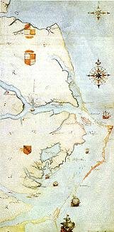
Experts from the First Colony Foundation and the British Museum in London discussed their findings Thursday at a scholarly meeting on the campus of the University of North Carolina at Chapel Hill. Their focus: the "Virginea Pars" map of Virginia and North Carolina created by explorer John White in the 1580s and owned by the British Museum since 1866.
"We believe that this evidence provides conclusive proof that they moved westward up the Albemarle Sound to the confluence of the Chowan and Roanoke rivers," said James Horn, vice president of research and historical interpretation at the Colonial Williamsburg Foundation and author of a 2010 book about the Lost Colony.
"Their intention was to create a settlement. And this is what we believe we are looking at with this symbol — their clear intention, marked on the map ..."
Attached to the map are two patches. One patch appears to merely correct a mistake on the map, but the other — in what is modern-day Bertie County in northeastern North Carolina — hides what appears to be a fort. Another symbol, appearing to be the very faint image of a different kind of fort, is drawn on top of the patch.
This blog is © History Chasers
Click here to view all recent Lost Colony Research Group Blog posts
Posted by
Historical Melungeons
at
5/04/2012 01:22:00 AM
![]()
Thursday, May 3, 2012
John White's Maps Revealing Secrets Over Four Centuries Old
It is a mystery that has perplexed
historians for more than 400 years - what ever became of the 120
settlers who tried to establish England's first colony on the north-east
coast of America?
Queen
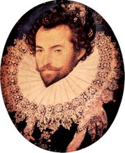
Elizabeth I and famed explorer Sir Walter Raleigh had hoped the
expedition in the 1580s would create a capital in the New World, but
something went terribly wrong.
The men, women and children simply
vanished - possibly massacred by native American Indians - any evidence
of a settlement disappeared and the infamous 'lost colony' became rooted
in American folklore.
But solving the centuries-old mystery
may have come a step closer this week after experts identified a
tantalising clue hidden in a map drawn by a man on that fateful voyage.
Read more: http://www.dailymail.co.uk/news/article-2138832/Is-Walter-Raleigh-s-lost-colony-drawn-invisible-ink-Clue-400-year-old-mystery-discovered-map-North-America.html#ixzz1tpWNFq2f
The ink, which is also disguised by a piece of paper glued to it, was likely put together using milk, citrus juice or urine, as was common at the time.
Its use during the 'lost colony expedition' also sheds light on an era of political suspicion at the time.
Read more: http://www.dailymail.co.uk/news/article-2138832/Is-Walter-Raleigh-s-lost-colony-drawn-invisible-ink-Clue-400-year-old-mystery-discovered-map-North-America.html#ixzz1tpVvn1o0
This blog is © History Chasers
Click here to view all recent Lost Colony Research Group Blog posts
Posted by
Historical Melungeons
at
5/03/2012 12:49:00 PM
![]()
Wednesday, May 2, 2012
John White Map Speaks to Modern Historians
The fate of Sir Walter Raleigh's famed "lost colony" in the New World – and the disappearance without a trace of more than 100 English settlers – has been an unsolved mystery for 400 years, a lost chapter of Anglo-American history. That so many men, women and children could simply vanish has become the stuff of American folklore. Many assume that they were either slaughtered by native American Indians or assimilated into their communities.
Now, a clue has emerged that experts hope could help solve the centuries-old mystery of the settlers' disappearance, and lead them to the site of what Raleigh and Queen Elizabeth I hoped would be a capital, the first English attempt at colonisation.
Concealed on an Elizabethan map of the east coast of North America, but now identified by the British Museum, is a hint at the colony's location drawn in what appears to be invisible ink, further disguised by a barely-discernible patch of paper glued to it.
Scientific tests have revealed that a lozenge, the symbol for a fort, was hidden on the map drawn by John White, who accompanied Raleigh's first attempts to establish a colony. White led the settlers who were to establish the "Cittie of Raleigh" of which he was intended to be governor.
Its concealment on the map reflects an age mired in political intrigue – Elizabeth I was then facing plots to place the Catholic Mary Queen of Scots on the English throne – and fears of such a map getting into the hands of court spies.
Invisible ink was concocted at that time from milk, citrus juice or urine, and usually revealed by applying heat.
An official announcement will be made today, but an excavation of the site, now farmland, is planned.
Cont.
Click here to view all recent Lost Colony Research Group Blog posts
Posted by
Historical Melungeons
at
5/02/2012 07:50:00 PM
![]()


