Pages

Tuesday, June 19, 2012

2012 Hatteras Dig

The 2012 Dig For those of you who follow along, the Lost Colony Research Group has sponsored archaeological digs now on Hatteras Island in 2009, 2010, 2011 and now, 2012. This year’s dig was somewhat different since we feel we have located the original site of the colonists on Hatteras Island in previous years. Additionally, we welcomed to our project this year Dr. Charles Ewen at ECU as well as two additional professional archaeologists.We have been very blessed. Our new project archaeologist is Jennifer Gabriel.As you also know, due to modern day pirates called treasure hunters, we have to keep the sites where we dig a well-guarded secret. Besides, the last thing a property owner wantsto find is their yard looking like swiss cheese when they return home one day, meaning that someone with a metal detector has trespassed and not only stolen historically important items, but ruined the area for subsequent archaeology. So while I can’t tell you exactly where we were, suffice it to say that we are still on Hatteras Island and we are still pursing the colonists. We actually dug in several location this year as our dig time in the field was expanded to two weeks. I will post two or three different blogs that shows some of our different activities and the group as well. We never had a better group, or a better time. Were it not for the extreme heat, the massive number of mosquitos and ticks, it was almost likea vacation.Refrains from the nursery rhyme, “ The Old Gray Mare, She Ain’t What She Used to Be ” played through my head every morning as I got my old, achy self out of bed to go and digsome more.However, this dig was blessed from the beginning. Dawn found a lucky penny and we saw a beautiful double rainbow from the deck of the house that we rented on the firs tmorning. Did I mention that there were 37 steps up and down. If not, I probably will mention that several times  Houses on Hatteras are built on stilts so that the flooding doesn’t damage the contents. However, that means that the first floor is really the secondfloor, and so on. Please ignore the small print below and go here to truly enjoy the full sized version:  

2012 Digging on Hatteras

  This blog is © History Chasers
Click here to view all recent Lost Colony Research Group Blog posts
Bookmark and Share

Monday, June 18, 2012

Crabfest 2012

By Roberta Estes

One of the Hatteras traditions is “pickin crab.”  In the local lingo, this means Blue Crab when it’s in season, which means now.  You can steam it yourself or you can order it by the bushel, fresh, steamed with Old Bay, and ready for eating.  That’s just what we did.  If you go to a restaurant, you’ll pay about $50 for a dozen.  Bought this way, it’s about $15 per person for about a dozen each, depending on the size.  Not only is this a great value, you get to participate in a communal eating experience second to none.  And in the process, we’ll even drop in an archaeology lesson.


Your crabs, freshly cooked and warm, arrive in a waterproof box.  The first thing that you must do is to find a way to completely cover the table.  Also, if carpet is involved, if you can, move the party outside (unless there are seagulls).  Seagulls love crab.  If this leaks into the carpet, you may smell the party for a long time afterwards.


Oh yes, and an order of hushpuppies is definitely in order as well.  Just don’t try to eat anything that requires silverware.  You’ll understand momentarily.


Dr. Charlie, a NC resident is demonstrating the technique of obtaining the crab from within the shell.  Hey, did you know these things came with a pop top?  Yes, all you need then is butter and beer to make the meal complete.

Normally, after the pop top thing, one uses nut crackers and picks to obtain the crab from the claw.  However, if you don’t have enough to go around and there is a wait for the tools, there are also alternate ways in to the crab…as aptly demonstrated by Jenn.  I love an innovative woman!!!

 
Here’s the entire table as we began.  Rolls of paper towels are mandatory.


 I can still hear Andy……”You’re doing bloody what and you’re eating it?  No, no way I can do that.”  Andy made a nice meal on hush puppies and some select clawmeat.  Apparently English crabs need less messy work up front!  By the end of the meal, he was already thinking about Crabfest Bideford as a huge public meal.  It’s hard to have more fun than this.

So here’s the archaeology lesson.  This week, we were digging in middens.  Middens are trash heaps, and you can tell a whole lot about the people that lived there from what they left behind.  Our crabfest table looks just like the middens we were digging, which bring to mind how the people then must have eaten as well.  We found bits of charcoal, which tells us they were cooking.  We found mounds of shells, mostly oyster shells, but intermixed with pot sherds and very large fish bones, mostly vertebrae the size of human vertebrae.  These people did not go hungry.  Unlike their land-dwelling counterparts, they did not have to rely on agriculture or hunting, they could rely on what the sea could and would provide for them.  Oyster beds existed near the Outer Banks islands.  We know this because of the oyster shell mounds in some middens.  This leads one to ask whether or not these oysters were being harvested for food or pearls, or perhaps both.  We know that pearls of different colors were coveted by the native people, and the larger, the better.

An oyster is mature in 3 years and their natural lifespan is about 6, that is, of course, unless either a human or a starfish interferes.   They are eaten only in the winter months.

We don’t find crab shells in middens.  They are much less durable and quite a bit thinner than actual mollusk shells.  But rest assured, the Native people had scenes that looked a lot like this…of course without the bottled beer and the “Trust Me I’m A Doctor” T-shirt.

 
The only bad thing about crabs is that you have to work so hard to get the meat out and it’s such a slow process that you never get full.  You just get tired of eating and your hands begin to hurt from the shelling and the Old Bay.


Here’s one happy crabber – Anne.
It takes a Hatteras Native to explain about how to obtain the crab most effectively.  Lessons are in order from Dawn.  Some of us needed remedial lessons too.


Jenn, innovating again.  Necessity is the mother of invention.

Alex just couldn’t be bothered with taking the shell off.
I think we’re finally done, but there are crabs left over.  Dawn is “pickin” the left over crabs for crabcakes.  Yum.  Seafood is never better than where is it caught and fresh.


And the trash, well, that’s a matter of perspective.  Jenn took a piece of crab outside and was immediately bombarded by the local seagulls.  They loved the pieces we didn’t eat.  Apparently, as far as they were concerned, we had not gotten all of the good stuff.  So, share one and share all.


This blog is © History Chasers
Click here to view all recent Lost Colony Research Group Blog posts
Bookmark and Share

Saturday, June 16, 2012

Who Are You, Really???

 by Janet Crain

Before you shell out big bucks for a population DNA test, trying to determine your ethnicity, be very aware. Costing more or less is not your best guide to their effectiveness. Both 23andMe and Family finder at Family Tree DNA of Houston use exactly the same chip. It tests over 700,000 markers and is the best on the market. 23andMe has lagged a bit behind but should be making some big changes very soon in drilling down into your ancestry. Family Finder is already doing this.

Population Finder
Reveals Ethnic Ancestry

Population Finder Population Finder is a report included with the Family Finder DNA test from Family Tree DNA. Today, this report is the single best option for measuring a person’s overall ethnic ancestry.

By comparing your DNA to that of global populations, it does what’s called a biogeographical analysis.

As part of Family Finder, it uses your autosomal DNA, which reflects the contributions of ALL your ancestors going back at least five or six generations.
Some companies market tests that claim to make finer distinctions than this. But their reports are based on such tiny population samples that the results are mostly wishful thinking.

Population Finder is the most scientifically credible ethnic DNA test available today.


http://www.dna-testing-adviser.com/population-finder.html

This blog is © History Chasers
Click here to view all recent Lost Colony Research Group Blog posts
Bookmark and Share

Friday, June 15, 2012

Proof Greenville was born in Bideford

Surprise discovery is ‘proof’ famous sea captain was born in Bideford

Thursday, June 14, 2012 
4:30 PM
The Gazette brings you an exclusive first look at the spot a local historian believes to be the birthplace of Sir Richard Grenville.

A COAT of arms discovered in a former pub has led to the remarkable discovery of the birthplace of a famous Bideford sea captain, according to local historians.
The exact birth place and date of the explorer Sir Richard Grenville, who died battling the Spanish Armada in 1591, has long been shrouded in mystery.
But now Grenville historian Andy Powell and historical researcher David Carter believe they have proved he was born in Bideford, and would be celebrating his 470th birthday tomorrow (Friday).
“Through months of painstaking research, we have proved beyond all reasonable doubt that Sir Richard Grenville was born in Bideford on June 12, 1542,” said former Bideford mayor Mr Powell.
"This could be the single most important discovery in Bideford’s history, and we will be launching a campaign to raise £1.2 million to save the building and open it as a Birthplace and Heritage Museum."
Andy Powell, Grenville historian 
“Furthermore, we have also found the site where Sir Richard Grenville’s house once stood at what is now 1-3 Bridge Street, which we believe was his birthplace.
Cont. click here

This blog is © History Chasers
Click here to view all recent Lost Colony Research Group Blog posts
Bookmark and Share

Monday, June 11, 2012

Visiting the Eastern Cherokee on the Qualla Indian Reservation in Cherokee, NC


Today was a wonderfully inspirational and educational fun day.  Come on along!!  We’re visiting the Eastern Cherokee Tribe on the Qualla Reservation.  You can read about them here:  http://nc-cherokee.com/ 
Here’s the tourism site:  http://visitcherokeenc.com/
Drove over the Smokies from Gatlinburg to Cherokee, NC.  Nothing on the TN side of the mountain looks anything like I remember it.  Gatlinburg was always commercial, but nothing like Pigeon Forge is today.  Wow.  Unrecognizable.  But once you cross the line from Gatlinburg to the National Park, it changes immediately and becomes peaceful.  It’s really a good thing they made it a park, otherwise it would all be developed.
 

Flowers blooming along the road, above.
On the NC side, the park abuts the Cherokee Indian Reservation.  You’d never know you were on a reservation if you didn’t know. It doesn’t resemble the western reservations whatsoever.  This just looks like a normal Appalachian town, with a focus on Native culture, of course.
I visited three locations, in addition to several stores.  The first was the reconstructed Indian Village.  This was simply pure joy.  The people here were exceptionally friendly and were all Native people living on the reservation today.  They were anxious to share about their culture and heritage.  My hour visit quickly turned into more than half a day and includes lots of extras.  They were very generous with their time.
Here is the village link, but I’ll tell you, this does not even begin to do it justice.  If you have to select just one thing to do in Cherokee, this is it!
The village is a reconstructed historic village, to scale, which includes several houses where traditional crafts and activities are being practiced.  In addition, there is a council house and a traditional town center where dancing occurs.
I went to the village first hoping to avoid the heat that was sure to be present in the afternoon.  Tribal members there doing traditional things like beads, pottery, carving, basketmaking, etc. 

The next photos shows the undercoat of a buffalo having been woven with beads during the weaving.  This was extremely soft.  I never thought of a buffalo being soft, but these are.  The mountain bison were smaller than western buffalo and became extinct in the 1790s.
Today the beadworkers use contemporary beads like the rest of us, but traditionally the cornbead was used.  It grows on a plant called the cornplant and it is hard when harvested.  There are some traditional beaded items, before the advent of European beads.  The cornbeads are the grey stand near the left.

Pottery of course was a village staple of all Native people.  Pots were used for everything from carrying water to cooking to being decorative and celebratory, like with the marriage vessel below.  The bride and groom would each drink from opposite sides, then the pot would be broken.
 

The carvers were quite interesting.  Everyone here knew a great deal about their history and heritage.  These men carve wood, bone and even feather shanks.  Notice the beautiful masks, below, one with a copper gorget.  The shells shown below are not carved.  They are crushed and used in the whitewash for their body paints.  On the coast, they aren’t used this way.  The difference in both use and culture was very interesting.

The pipe below is carved in the shape of an eagle.
The prepwork involved in basket-making and weaving is unfathomable.  By the time they begin the basket itself, much of the work is done.   Some baskets are actually watertight.

If I ever thought I wanted to do basketwork, this cured me and instilled a great respect for those who do.
The flintknappers were very interesting.  Of course, most of the food supply was dependent on arrowheads.  Some were squared off and some were round.  The ones meant for food were rounded at the shank so they could be pulled out.  The squared ones were meant for enemies and removing by pulling them out wasn’t possible.  The man below is knapping flint by knocking off the edges to achieve a sharp blade type edge.

This man also demonstrated the use of a blowgun.  Poisons weren’t used, because the animal was to be used for food.  He was quite accurate. 
 
 Cont. here:
http://nativeheritageproject.com/2012/06/11/visiting-the-eastern-cherokee-on-the-qualla-indian-reservation-in-cherokee-nc/


This blog is © History Chasers
Click here to view all recent Lost Colony Research Group Blog posts
Bookmark and Share

Sunday, June 10, 2012

2012 Hatteras Archeology Dig

 It is not easy trying to locate people who disappeared 425 years ago. One of the problems is just getting there to the place it happened. Here we get a first hand report by Robert Estes of the difficulties she encountered on day one of her trip to the 2012 Hatteras Archeology Dig.  JC


~~~~~~~~~~~~~~~~~~~~~~~~~~~~~~~~~~~~~~~~~~~~~~~~~~~~~~~~~~~~~~~~~~~~~~~~~~~~~~
And so, the adventure has begun. Every year, and every dig, has seemed to have a unique set of challenges. In almost every case, we’ve had some weather catastrophe. We’ve had 2 hurricanes, one that washed out the roads, a volcano erupted, a snowstorm, and Andy’s plane was struck by lightning. Other than that, nothing major….

After that, you think, what is left to happen? Well, I have the answer….a rockslide…really, a landslide. They called it a massive landslide. I thought at first there were rocks on the highway, but when I arrived, it was even more frightening. The entire southbound roadway was gone….entirely…..slid down the mountain. All you could see what a wonderful view of the next mountain. Frightening.


Other than my GPS getting itself entirely confused in Knoxville, I arrive in Pigeon Forge with no further excitement. But I’m surely going to drive on the inside lane, not by the guardrail, from now on.


But it seems there is more to the story. WBIR 10 News reports:


MAY 9, 2012 – TENNESSEE – TDOT has shut down all but one northbound lane of Interstate 75 between mile markers 141 and 144 in Campbell County. The earliest any southbound lanes will reopen is Thursday. The shut down comes because the embankment that collapsed beneath I-75 South on March 8 has now grown to threaten the median and northbound lanes. TDOT brought in the big gun to defend I-75 North by hiring an emergency repair contractor from Grand Junction, Colorado. “Myself and my crew got a call yesterday [Monday] and we arrived late last night,” said Nate Beard, vice president and engineer with Soil Nail Launcher, Inc. Beard’s crews will battle a beast of a mountainside with an oversized air gun originally built by the British military. “It is a big compressed air launcher that would launch nerve gas canisters up to seven miles,” said Beard. “It has been modified to launch soil nails, which is a 20 foot long, 1.5 inch diameter steel tube. We build that compressed air up to 3000 PSI, pull the trigger, and then it accelerates into the ground at 250 miles per hour.”


 In Campbell County, soil nail launcher crews are taking aim at a moving target. “The big challenge here is it is an actively moving landslide. I walked across this road at midnight and at 2:00 in the morning all of that material had fallen down to the bottom of the slope,” said Beard. “Our top priority is protecting the northbound lanes. We’ll launch around 300 soil nails. We’ll put them in a really tight spacing. It works with the soil particles to confine them and create a beam effect, which then supports the interstate. It takes a lot of those loading and driving forces off the landslide.” Beard said crews should finish nailing the northbound lanes by Wednesday morning. Then they will hammer away at the southbound lanes with even larger soil nails. “The south lanes can use nails that are 50 to 60 feet long and two inches in diameter,” said Beard. “You drive along these roads and they are perfect and they are flat, but they are on the edge of a cliff. A lot of people take that for granted, but the fact is there are frequently things like launched soil nails beneath the roads to keep them secure and stable.”

So I was driving on the unstable northbound lanes on top of a migrating, creeping landslide. I feel much better. The photo below shows the highway, down the embankment, with a few trees and such. I wonder if there are any vehicles down there that were on the road when it collapsed. Driving where there is suddenly no road is the stuff nightmares are made of!


Pigeon Forge


The first stop is Pigeon Forge, which doesn’t even resemble the Pigeon Forge in my memory. The road used to be 2 lane, to begin with, and while there were some stores, there are now outlet malls and it looks more like Florida near Disney World than Tennessee. I guess that would be the effects of Dollywood. Glad to be moving on to Cherokee, NC tomorrow and glad I didn’t try to drive it tonight.


This blog is © History Chasers
Click here to view all recent Lost Colony Research Group Blog posts
Bookmark and Share

Tuesday, May 8, 2012

Register for the East Carolina University Lifelong Learning Program

 Greenville Daily Reflector
Today is the deadline to register for the East Carolina University Lifelong Learning Program's The Lost Colony and More Tour, scheduled for June 11-12 in Nags Head and Manteo. To register or for more information, call 328-9198 or visit 


http://www.ecu.edu/llp

This blog is © History Chasers
Click here to view all recent Lost Colony Research Group Blog posts
Bookmark and Share

Monday, May 7, 2012

The Chowan Fort Discovery on the John White Map


The Chowan Fort Discovery on the John White Map

by Roberta Estes


First we'd like to congratulate Brent Lane with the First Colony Foundation for his keen eye in spotting the anomaly on John White's map drawn of "Virginia" in 1585-1586 and the British Museum for their fine detective work in locating the fort icon on the map, under patches, shown below. 


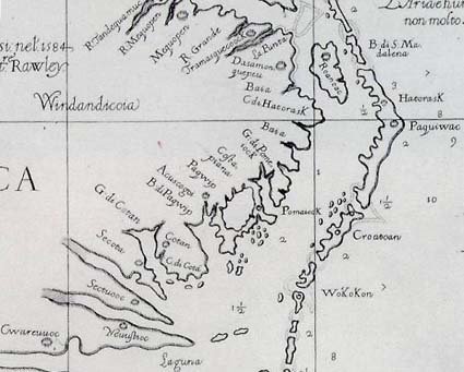
An enlargement  of the fort location on the map is provided, below, by the British Museum.  There were actually two fort icons, one on top of the other, and two layers of patches, per  their published technical results.  


This new piece of information is both important and enlightening....and like many news items, has been blown a bit out of proportion.  It has been reported that this is the location where the lost colonists relocated, which at this point, is certainly a leap of logic.   Let's take a look at what was found, what we know, and the possibilities of what it might mean.

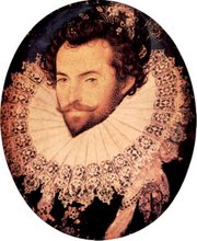
John White was an artist.  He accompanied the 1584 and 1585/1586 military expeditions to what was then called "Virginia."  Those expeditions, headquartered off of Roanoke Island, were specifically to scout a suitable location for establishing a colony, the "Citie of Raleigh."  The location chosen was in the Chesapeake region, not Roanoke Island, but a snafu in 1587 resulted in the colonists being literally abandoned in August  on Roanoke Island where the following supply ships would never find them.  They sent John White, then the governor of the "Citie of Raleigh" back to England for supplies which they expected to arrive in the spring of 1588. 


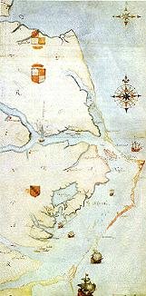
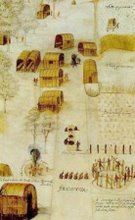
The above map is John White's map drawn during the 1585-1586 military voyage of discovery.  The military men spent quite a bit of time exploring the region, meeting the natives, learning about the region and potential locations for a permanent colony. 

John White, in 1587 was only on Roanoke Island for a few days before departing again for England, so we know this map was not drawn on that trip.  Prevented from returning to Roanoke in 1588 and 1589 by England's war with Spain, when he was able to return in 1590, he found the colony removed and the message "CRO" and "Croatoan" carved on both a tree and fort post for him.  If they relocated to the Chowan River location, why would they have carved Croatoan and CRO at the fort?

Before White left, the colonists has discussed moving "50 miles into the main."  White told us this, but he never revealed the location.

However, the message they left for John White to find up on his return was "Croatoan."  They had done as they had promised they would, letting John White know where they went.  White, in his own words from his journal, was “greatly joyed that I had safely found a certain token of their safe being at Croatoan which is the place where Manteo was born”, “the island our friends.” 

John White could not have drawn this map in 1590, as he was only on Roanoke Island and only for a day or so before a hurricane blew the ship back to England.  Therefore, John White's original map had to have been drawn no later than 1586.  However, John could have modified this map anytime between then and his death in 1593.  Someone else could have modified the map, then or later.  But, assuming the modifications were made by White, why would John White cover this location?  And what does this fort location mean?

I've read in several news sources in the past few days that this is the final destination of the colonists and indeed, where they went.  While this is certainly one of the possibilities, there are also others, and I'd like to briefly touch upon the various possibilities and the logic for each.

1.  Military Fort - It's certainly possible that at one time the military colonists of 1585/1586 were planning to built a fort further inland.  If so, this initially looks like a great location, at the juncture of two rivers and fairly easy to defend.  However, there is no indication a fort was ever built there....and the resulting "coverup" patch on the map may indeed only reflect that change of plans and the lack of an eraser.  John White worked in paint, and there was no "White Out" or erasure for that.  His only choice if a planned location did not develop would have been to put a patch over the location.  A second patch on this map indeed is only to show changes to the coastline on the map.

2.  "50 Miles Into The Maine" - This fort icon on the map indeed may be the fabled location recorded in John White's own words, "at my last departure from them...for at my coming away, they were prepared to remove 50 miles into the maine."  Given that John White returned to England and was not with the colonists, the only piece of information he could convey is the PLANNED location of "50 miles into the maine." 

When White left, the relations with the Indians were deteriorating rapidly.  The English had just beheaded Wingina and killed many of his villagers.

John White never knew where the colonists actually went, although he believed, based on what he found, that they went to Croatoan and were safe.  He had arranged with the colonists before he left for a secret token, a cross, to be carved if they were in danger or under duress when they left Croatoan Island.  No crosses were found.  But a clear location, carved twice, was found.

If this fort was the "50 miles into the maine" location, why might John White cover it up? 

There are really only two options.  First is that it was no longer valid, meaning that further discussions or investigation caused them to change their mind about that location.  However, it's worth noting that no other location is marked and that this region does fit the "50 miles" criteria fairly accurately. 

The second possibility is to hide the location, probably from the Spanish.  Espionage was common in England at this time and the Spanish were actively seeking the colony in order to destroy them. 

3.  The only thing shown on the map is a fort symbol.  We don't know if this was originally meant to be a military outpost, the new "Citie of Raleigh" or something else.  We cannot assume that this fort was ever built.  In fact, there are no oral histories, or local histories or even rumors of a fort in this location.  It would be difficult to built a fort of the size required to house 117 people without some remnant remaining and being recorded in some type of record. 

By 1654, explorers from the Jamestown region were active in this same area and no fort or remnant of a fort was ever reported, less than 65 years later. 

It should be noted that the Tuscarora have an oral tradition of being descended from the Colonists.  The Hatteras Indians are recorded by Lawson in 1701 as both having an oral tradition along with grey eyes and lighter hair, unlike any other Indians.

4.  In terms of relations with the Indians, the military expedition of 1585-1586 was a disaster as what is known of the 1587 settlement before White departed for England. 

The 1585/1586 military colonists burned the village of Aquascogoc, destroying the corn crop, and therefore the food of the people for the upcoming winter.  These actions were the precipitating factor in the murder of George Howe, one of the 1587 colonists upon their arrival.  In retaliation for Howe's death, 1587 colonists beheaded Wingina, the chief, and massacred the people in his village across the bay from Roanoke island where they had resettled after leaving Roanoke Island where the English fort was located. 

For a refresher of the events leading up to the 1587 colony, please visit our website at this link:  http://www.rootsweb.ancestry.com/~molcgdrg/faqs/lcstory.htm

Given these aggressions, would it be logical for the colonists to move to a location where they are surrounded by three tribes of Indians, at least one of them known to be hostile and a second likely to be?

Taken from Andy Powell's book, "Grenville and the Lost Colony of Roanoke," the following is excerpted from the transcript of the original Barlowe journal from 1585-1586 which was included in the Hakluyt records compiled in 1589.  Several men, with Manteo, rowed upstream in the Roanoke River to the Chowan and up the Chowan for some distance, a total of about 140 miles hoping to find gold or the location of where gold could be found.  The newly discovered fort icon on the map is at the confluence of those two Rivers.  Here's what Barlowe had to say about that exploratory trip upriver.

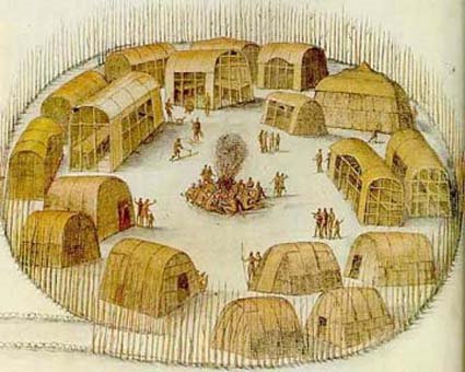
"...on the one side whereof stands a great town, called Chowanoake, and the Lord of that town and country is called Pooneno: this Pooneno is not subject to the King of Wingandancoa, but is a free Lord. Beyond this country, there is another king, whom they call Menatoan, and these three Kings are in league with each other."

Apparently, word preceded their arrival, because many of the Indian towns were entirely deserted.  When leaving, the Indians took their food supplies with them.  Not only did the Englishmen want to learn where valuable ores might be found (gold and silver), they also wanted food, a commodity in scarce supply.  They had not taken enough food with them and presumed they would be able to obtain food from the Indians en route.  In order to obtain cooperation, they kidnapped Chief Menatonon and his son.  In Barlowe's words:

"I took a resolution with myself, having dismissed Menatonon upon a ransom agreed for, and sent his son into the Pinnesse to Roanoak, to enter presently so far into that River with two double wherries, and forty persons one or other, as I could have victual to carry us, until we could meet with more either of the Moratiks, or of the Mangoaks which is another kind of Savages, dwelling more to the Westward of the said River: but the hope of recovering more victual from the Savages made me and my company as narrowly to escape starving in that discourse before our return, as ever men did that missed the same."

Note on White's map the label, Moratuc, just below and across the river from the fort icon.  These Indians were not friendly to the military colonists.  The Chowanac weren't terribly happy with them either.  Kidnapping the king and his son did not endear the English to the Native people.  Barlowe again:

"I having been enforced to make him privy to the same, to be served by him [Menatonan] of a guide to the Mangoaks, and yet he did never rest to solicit continually my going upon them, certifying me of a general assembly even at that time made by Menatonon at Choanoak of all his Weroances, and allies to the number of 3,000 bows preparing to come upon us at Roanoak and that the Mangoaks also were joined in the same confederacy, who were able of themselves to bring as many more to the enterprise."

Nor were these tribes friendly towards each other.  Menatonan's son had also been a prisoner among the Mangoaks, later known as the Tuscarora.  The English sought to find the Mangoaks as they wanted to take some of the people prisoner, as described by the following passage from Barlowe:

"And that which made me most desirous to have some doings with the Mangoaks either in friendship or otherwise to have had one or two of them prisoners, was, for yet is it a thing most notorious to all ye country, that there is a Province to the which said Mangoaks have recourse and traffic up that River of Morattico [Roanoke], which has a marvellous and most strange Mineral. This mine is so notorious amongst them, as not only to the Savages dwelling up by the said river, and also to the Savages of Choanoke [Chowan], and all them to the westward, but also to all them of the main: the countries name is of same, and is called Chaunis Temoatan."

The fabled mines of Chaunis Temoatan have never been found.

When they did eventually find the Indians which they sought, this was the results, again told by Barlowe:

"...we heard certain Savages call as we thought, Manteo, who was also at that time with me in boat, whereof we all being very glad, hoping of some friendly conference with them, and making him to answer them: they presently began a song, as we thought in token of our welcome to them: but Manteo presently betook him to his piece [probably a gun], and told me that they meant to fight with us: which word was not so soon spoken by him, and the light horsemen ready to put to shore, but there lighted a volley of their arrows amongst them in the boat."

The reputation of the English had preceeded them.  The Indians on Roanoke island presumed the English would die of starvation.  They did not, and returned to the island with Menatonan's son as hostage.

When the English settlers arrive in 1587, hard feelings remained among the various mainland tribes.  George Howe was murdered in retaliation for the burning of the village of Aquascogoc.  The English then escalated the conflict and massacred the inhabitants of Wingina's village.  This action in 1587 just prior to John White's departure for England, did nothing to endear the English to the Native people.  By this time, they had alienated nearly all of the neighboring Native tribes by either warfare, kidnapping or burning their villages.  They were sitting on a tenderbox and the only tribe who would provide them with assistance would be Manteo's people, the Croatoan. 

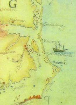
Given this information, I've plotted the locations of the events noted above.

1=kidnapping of Menatonan and his son - both Chowanac
2=location of Moratuc [Tuscarora] who fought with Chowanac and fired upon the English.
3=location where English massacred Wingina and the people of his village
4=location of Aquascogoc, burned by the English
5=Roanoke Island, the site of the 1584 and 1585/86 military forts and where George Howe was murdered by Natives in revenge in 1587.  Subsequently, Wingina was murdered across the bay.
6=Croatoan, the location given by the colonists for John White to find when leaving the fort on Roanoke Island

Given the volatile situation in 1587, would you locate 117 English non-military colonists between locations one and two in a fort, or on Hatteras Island among friendly Indians?


 We can discuss logic and pros and cons today about whether the fort on the map was ever built, and for what purpose, but the real truth about the fort, if it ever existed in reality, lies someplace under about 1200 acres, including a golf course, near Salmon Creek in a location known as Avoca in present day Bertie Co., NC.  We are excited about an upcoming archaeological dig being planned by the Lost Colony Foundation and look forward to their findings. 

 Click on the maps for much larger versions

The above map images are copyright British Museum 


This blog is © History Chasers
Click here to view all recent Lost Colony Research Group Blog posts
Bookmark and Share