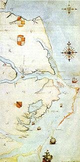
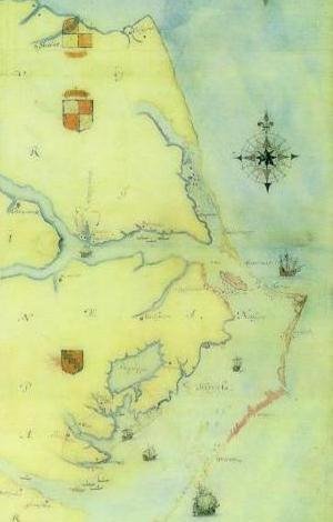
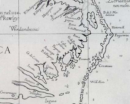
In 1590 Theodor De Bry published Part I of his America, which included several of his engravings based on drawings of the New World by John White. Notable among them is a map of the east coast of North America from the lower Chesapeake Bay south past Cape Lookout. Three probable sources of this collaborative map are extant: a crude pen-and ink map, perhaps by Ralph Lane, and two of an unknown number of White's detailed watercolor sketch maps — one, on a large scale, covering much the same area as the engraving; the other, on a small scale, showing southeastern North America and part of the West Indies.
Some features unique to the White-De Bry are corrections; others are errors; still others may be based on sketch maps now lost. Following is the key to the White-De Bry map which was taken, with many liberties, from Appendix I of David B. Quinn's Roanoke Voyages (London, 1955).
MAP KEY found here:
skip to main |
skip to sidebar

Extremely Honored


All that is necessary for the triumph of evil is that good men do nothing.
~ Edmund Burke


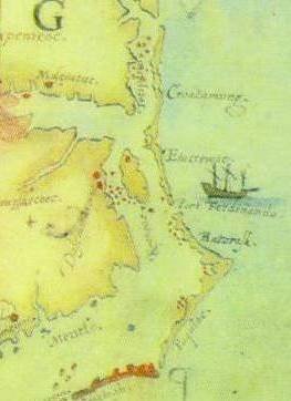
These two maps (above and below) may be very important concerning the research of the Lost Colony. Please note the Alligator River with Indian site indicated at the head of the river on the southeast side. This village has been measured and is exactly 50 miles from Roanoke Island.


This blog contains links to other sites on the Internet. This does not constitute approval of these sites. They were deemed interesting at the time we viewed them. Websites do change over time so if any are no longer of value, inappropriate or otherwise unsuitable, please notify us. *Additionally clicking on Next Blog in the toolbar at the top of this page takes you COMPLETELY OFF this page. We have no control of the content of the sites you may encounter after you leave this site. You may encounter objectionable material. This is out of our control. *


Copyright 2007-2008
All Rights Reserved
~ History ~ Genealogy ~ Archaeology ~
Pages
Translate
Subscribe via email
Followers
Hatteras Island Genealogical and Preservation Society
Genealogy society founded for those whose roots emerged from the sands of Cape Hatteras, NC. History hunter, Dawn Taylor, blogger, is the President of the Hatteras Island Genealogical and Preservation Society and Researcher for the Lost Colony Genealogy and DNA Research Group. Also the Co-Admin for the Hatteras Families DNA projects, under the LCRG's umbrella.
http://hatgensoc.wordpress.com
http://hatgensoc.wordpress.com
Search This Blog
Become a Fan at Facebook
Lost Colony of Roanoke DNA Project on Facebook
Extremely Honored
Where Were the Lost Colonist From?
Comprehensive Collection of Roanoke and Jamestown Books
Visit the The Lost Colony Genealogy and DNA Research Group Main Website
Op-Ed Articles Notice
In the interest of a balanced viewpoint, this blog will occasionally publish op-ed articles by guest authors. These articles may not, necessarily, reflect the opinion of the editors.
My Blog List
-
-
-
-
Merry Christmas6 years ago
-
-
My biggest breakthrough ever7 years ago
-
-
FEEDJIT Live Traffic Feed

Contact the Editors
Search the Family-Friendly Network
Names used in the Lost Colony of Roanoke Project
Surname-Source
Allen -- Colonist roster
Alligood -- Families of Interest
Archard-- Colonist roster
Archard -- Families of Interest
Armstrong -- Families of Interest
Arthur -- Colonist roster
Austin -- Families of Interest
Bailie -- Colonist roster
Barber, Barbour -- Families of Interest
Barrow -- Families of Interest
Beasley -- Families of Interest
Bennet -- Colonist roster
Bennet -- Families of Interest
Berde -- Colonist roster
Berry -- Families of Interest
Berrye -- Colonist roster
Bishop -- Colonist roster
Blount -- Families of Interest
Borden -- Colonist roster
Boyd -- Families of Interest
Bragg -- Families of Interest
Bridger -- Colonist roster
Bridger -- Families of Interest
Bright -- Colonist roster
Bright -- Families of Interest
Brooke -- Colonist roster
Brooks -- Families of Interest
Browne -- Colonist roster
Bryant -- Families of Interest
Buck -- Families of Interest
Burden -- Colonist roster
Butler -- Colonist roster
Butler -- Families of Interest
Cage -- Colonist roster
Cahoon -- Families of Interest
Cain -- Families of Interest
Carawan -- Families of Interest
Caroon, Carron -- Families of Interest
Carrow -- Families of Interest
Chapman -- Colonist roster
Chapman -- Families of Interest
Chavis -- Families of Interest
Cherry -- Families of Interest
Cheven -- Colonist roster
Collins -- Families of Interest
Colman -- Colonist roster
Cooper -- Colonist roster
Cooper -- Families of Interest
Cotsmur -- Colonist roster
Cox -- Families of Interest
Crisp -- Families of Interest
Croom -- Families of Interest
Cuttler -- Families of Interest
Daniel -- Families of Interest
Dare -- Colonist roster
Darige -- Colonist roster
Darige -- Families of Interest
Dixon -- Families of Interest
Dorrell -- Colonist roster
Durrance -- Families of Interest
Durrant -- Families of Interest
Dutton -- Colonist roster
Earnest -- -- Colonist roster
Edwards -- Families of Interest
Elks -- Families of Interest
Ellis -- Colonist roster
Ellis -- Families of Interest
English -- Colonist roster
Evans --Families of Interest
Farre -- Colonist roster
Farrow -- Families of Interest
Fitspatric -- Families of Interest
Florrie -- Colonist roster
Forbs -- Families of Interest
Gaylord -- Families of Interest
Gibbes -- Colonist roster
Gibbs -- Families of Interest
Glane -- Colonist roster
Gramme -- Colonist roster
Griffin -- Families of Interest
Gurganus -- Families of Interest
Gurkin -- Families of Interest
Hardison -- Families of Interest
Harris -- Colonist roster
Harris -- Families of Interest
Harviem -- Colonist roster
Harvie -- Families of Interest
Harvye -- Colonist roster
Hassell --Families of Interest
Hawkins --Families of Interest
Hedgepath -- Families of Interest
Hemmington -- Colonist roster
Hewet -- Colonist roster
Hill -- Families of Interest
Hodges -- Families of Interest
Howe -- Colonist roster
Hudson -- Families of Interest
Humfrey -- Colonist roster
Hynde -- Colonist roster
Jackson -- Families of Interest
Jennette --Families of Interest
Jerkins -- Families of Interest
Johnson -- Colonist roster
Johnson -- Families of Interest
Jones -- Colonist roster
Jones -- Families of Interest
Kemme -- Colonist roster
Keys -- Families of Interest
King -- Families of Interest
Lasie -- Colonist roster
Lathan -- Families of Interest
Lawrence -- Colonist roster
Leary -- Families of Interest
Little -- Colonist roster
Long -- Families of Interest
Lowery -- Families of Interest
Lucas -- Colonist roster
Lucus -- Families of Interest
Mackey -- Families of Interest
Mann -- Families of Interest
Mannering -- Colonist roster
Martyn -- Colonist roster
Mayo -- Families of Interest
McCoy -- Families of Interest
Merrimoth -- Colonist roster
Midgette -- Families of Interest
Moor -- Families of Interest
Mullins -- Families of Interest
Myllet -- Colonist roster
Mylton -- Colonist roster
Newton -- Colonist roster
Nicholas -- Families of Interest
Nicholes -- Colonist roster
Nicols -- Families of Interest
Norman -- Families of Interest
Padgett -- Families of Interest
Pain -- Families of Interest
Paramore -- Families of Interest
Patrick -- Families of Interest
Pattenson -- Colonist roster
Payne -- Colonist roster
Payne -- Families of Interest
Perry -- Families of Interest
Phevans -- Families of Interest
Phevens -- Colonist roster
Philpatrick -- Families of Interest
Pierce -- Colonist roster
Pierce -- Families of Interest
Pinkham -- Families of Interest
Pollock -- Families of Interest
Powell -- Colonist roster
Powell -- Families of Interest
Prat -- Colonist roster
Pugh -- Families of Interest
Respass -- Families of Interest
Ricks -- Families of Interest
Rollinson -- Families of Interest
Rufoote -- Colonist roster
Russell -- Families of Interest
Salter -- Families of Interest
Sampson -- Colonist roster
Sawer -- Families of Interest
Scot -- Colonist roster
Scot -- Families of Interest
Shaberdge -- Colonist roster
Shephard -- Families of Interest
Simmons -- Families of Interest
Smart -- -- Colonist roster
Smith -- Colonist roster
Smith -- Families of Interest
Smart -- Colonist roster
Sole -- Colonist roster
Sparrow -- Families of Interest
Spendlove -- Colonist roster
Spenser -- Families of Interest
Squires --Families of Interest
Starte -- Colonist roster
Stevens -- Colonist roster
Stevens -- Families of Interest
Stilman -- Colonist roster
Stilman -- Families of Interest
Sutton -- Colonist roster
Sutton -- Families of Interest
Swann -- Families of Interest
Tan -- Families of Interest
Tappan --Colonist roster
Tarkington -- Families of Interest
Taverner -- Colonist roster
Taylor -- Colonist roster
Tetterton -- Families of Interest
Thomas -- Families of Interest
Tom, Toms -- Families of Interest
Tomkins -- Colonist roster
Topan -- Colonist roster
Tuley -- Families of Interest
Turner -- Families of Interest
Tydway -- Colonist roster
Viccars -- Colonist roster
Viccars -- Families of Interest
Wahab -- Families of Interest
Wallis -- Families of Interest
Warner -- Colonist roster
Warren -- Colonist roster
Warren -- Families of Interest
Waters -- Colonist roster
Waters -- Families of Interest
Welch(s) -- Families of Interest
White -- Colonist roster
White -- Families of Interest
Wildye -- Colonist roster
Wilkinson -- Colonist roster
Willes -- Colonist roster
Williams -- Families of Interest
Wood -- Colonist roster
Woolard -- Families of Interest
Wotton -- Colonist roster
Wright -- Colonist roster
Wyles -- Colonist roster
Wyles -- Families of Interest
Wythers -- Colonist roster
Recommended Websites:
- East Carolina Roots
- Lumbee Indian Fact Sheet for Kids
- The Lumbee Indians, The Lost Colony of Roanoke and the Goins Family
- Lost Colony DNA Project FAQ's
- The Genetic Genealogist
- Comprehensive List of Resources
- Digging for the Truth: Lost Colony of Roanoke Podcast
- A Brief and True Report of the New Found Land of Virginia
- A LIST OF ALL PARTICIPANTS IN THE ROANOKE VOYAGES
Blogging Against Abuse
Recommended Books
Recommended Books
- Searching for Virginia Dare
- Roanoke Island: the Beginnings of English America by David Stick
- Set Faire for Roanoke: Voyages and Colonies 1584-1590 by David B. Quinn
- First Colonists: Documents on the Planting of the First English Settlements in North America, 1584-1590 by David B. Quinn
- Big Chief Elizabeth: The Adventures and Fate of the First English Colonists in America by Giles Minton
- Virginia Adventure by Ivor Noel Hume
- Jamestown, the Buried Truth by William Kelso
- A Land as God Made It by James Horn
- Walter Ralegh's Virginia: Roanoke Island and the Lost Colony by Aleck Loker
- Roanoke: Solving the Mystery of the Lost Colony by Lee Miller
- The Lost Colony of Roanoke by Jean Fritz
16th Century Signet Ring

1584 Map of Chesapeake Bay by John White

Map Showing Port Fernando

These two maps (above and below) may be very important concerning the research of the Lost Colony. Please note the Alligator River with Indian site indicated at the head of the river on the southeast side. This village has been measured and is exactly 50 miles from Roanoke Island.
John White 1685

Labels
- ;shawnee (1)
- · Books (1)
- · History (1)
- · Nonfiction (1)
- · People (1)
- · Reading (1)
- · World (1)
- 15 years (1)
- 1572 (1)
- 1586 (1)
- 16th century (1)
- 1889 (1)
- 23andMe (8)
- A Novel of America (1)
- Abraham (1)
- activities (1)
- activity (1)
- adam perry (1)
- adoptee (1)
- adoption (2)
- Adrian Paul (1)
- advanced ground penetrating system (1)
- adventure (1)
- africa (1)
- African (2)
- African DNA (13)
- African-American Lives (1)
- AfricanDNA.com (2)
- aishihik (1)
- alaska (1)
- Albemarle (5)
- Alden Vaughan (1)
- Alexander Gregg (1)
- Algonkian (1)
- Algonquian Indians (3)
- Almon Wheeler Lauber (1)
- Altai (1)
- amazon rainforest (1)
- american indian (7)
- American Philosophical Society (1)
- Amerindian (1)
- Amy Ridenour blog (1)
- Ana Oquendo Pabon (1)
- ancestor (1)
- ancestors (1)
- ancestry (1)
- ancestry dna (3)
- anchor (1)
- ancient DNA (1)
- andy griffith (3)
- Andy Powell (2)
- anne pool (1)
- anne poole (1)
- appalachian (1)
- apprentice (1)
- Archaeological Sites (3)
- Archaeological Sites North Carolina (2)
- Archaeologists (1)
- Archaeology (8)
- Archeology (6)
- Art (1)
- Arthur Barlowe (5)
- artifact (4)
- artifacts (9)
- ataxia (1)
- Atlanta (1)
- Atlantic Seaboard (2)
- australia (1)
- autosomal (6)
- autosomal test (1)
- autosomes (1)
- bacon's rebellion;indentured servant (2)
- badge (1)
- banker ponies (2)
- Barbados (2)
- barbara hird (1)
- basques (1)
- bath county (1)
- Baylus Brooks (1)
- bc iceman (1)
- beechland (1)
- benefit (2)
- berengia (1)
- bering land bridge (1)
- berry site (1)
- bideford (7)
- Bideford Mayor Jamie Daniels (1)
- bideville (1)
- Biology (1)
- birthday (5)
- black beard (1)
- black eyed peas (1)
- Black History Month (2)
- Blackbeard (4)
- blackwater river (1)
- bladen (1)
- Blog (3)
- Bloggers unite (1)
- Bloggers Unite for Human Rights (1)
- blood (1)
- bodie island (1)
- bone fragments (1)
- Brayboy (1)
- britain (1)
- British Museum (1)
- broadway (1)
- BROOK SHIELDS (1)
- Budweiser (1)
- burials (1)
- burke county (2)
- Burned database (1)
- Butler (1)
- byrd (1)
- cannon (1)
- Caribbean (1)
- Carolina (1)
- carolinas (1)
- carrituck (1)
- CART (1)
- carteret (1)
- cartography (1)
- Cartouca (1)
- carvel (1)
- Catawba (1)
- Catawba river (1)
- Cayuga (1)
- celebration (1)
- celebrities (1)
- celebrity (1)
- ceramics (1)
- chairman (1)
- champagne tribe (1)
- charles c. mann (1)
- Chatooka (1)
- chavers (1)
- cheraw (1)
- cherokee (4)
- Cherokee Communities of the South (1)
- chesapeake (2)
- Chickahominy (1)
- children (1)
- China (1)
- Chinese (1)
- chowan river (4)
- Chowanac (1)
- christmas (3)
- citee of raleigh (2)
- civil war (1)
- civil war history (1)
- clinker built (1)
- clovis (1)
- coastal (1)
- Colonial and State Records of N. C (1)
- Colonial Plats (1)
- colonies (3)
- colony (1)
- columbus (2)
- confederate (1)
- conference (3)
- contact (1)
- copper (2)
- cora tree (1)
- Cornwallis (1)
- costume replacements (1)
- costume shop (1)
- costumes (2)
- country (1)
- court records (1)
- Creek (1)
- Croatan (5)
- Croatan Indians (6)
- Croatans (5)
- croatia (1)
- Croatoan (7)
- croatoan hatteras (5)
- Croatoans (4)
- Crotans (1)
- crotoans (1)
- culture (4)
- cumberland (1)
- Cumberland Gap Homecoming (1)
- currituck (1)
- Cyndi's list (1)
- daniels day (1)
- Dare County (1)
- dare stones (2)
- database (1)
- Daughters of the Revolution (2)
- David Beers Quinn (2)
- david moore (1)
- de Soto (3)
- Dear Myrtle (1)
- death certificates (1)
- decodeme (2)
- deftware (1)
- devon (2)
- dictionary (1)
- dig (2)
- digital textbook (1)
- discovery (1)
- dismal swamp (1)
- DNA (48)
- DNA Projects (4)
- dna test sale (1)
- DNA testing (1)
- Don Luis (1)
- Dr. Mark Horton (1)
- Dr. Mehmet Oz (1)
- drake (3)
- drama (2)
- drought (1)
- early records NC (2)
- East Asian (3)
- Eastern (1)
- eastern north carolina (1)
- eastern seaboard (1)
- ECU Field Station (1)
- Edenton (1)
- Edmund Ruffin (1)
- Edward Hyde (1)
- eecology (1)
- Elaine Bliss quilter (1)
- Eleanor Dare (2)
- Elizabeth Alexander (1)
- elizabeth I (1)
- elizabethan (3)
- EMMITT SMITH (1)
- Encyclopedia of Genealogy (3)
- England (8)
- English (4)
- English and Algonquin (1)
- episcopal church (1)
- Ernie's (1)
- Errol Lincoln Uys (1)
- ethnic (1)
- European contact (2)
- eva longoria (1)
- evolution (1)
- exonumia (1)
- faces of america (2)
- family finder (1)
- family history month (1)
- Family Tree DNA (10)
- Family Tree DNA. (7)
- fee (1)
- fernando pass (2)
- Fernbank Museum (1)
- Fernbank Museum of Natural History (1)
- finds (1)
- fine arts (1)
- first ancient human sequenced (1)
- first colony (2)
- first colony foundation (2)
- first nations (1)
- fishing (1)
- flanders field (1)
- fort christiana (1)
- fort raleigh (6)
- fort san juan (1)
- fort st. george (1)
- Free (1)
- free persons of color (1)
- free resources (1)
- funeral rites (1)
- funk heritage center (1)
- gene (1)
- Genealogy (17)
- Genealogy archives (2)
- genealogy blog (1)
- genealogy. (1)
- Genetic (2)
- Genetic Genealogy (9)
- Genetic Genealogy;family tree dna (1)
- genetic testing (3)
- genetics (1)
- genghis kahn (1)
- genome (2)
- Genome research (2)
- GENUKI (1)
- geographic project (1)
- geography (1)
- georgia (2)
- ghost busters (1)
- ghost hunters (1)
- Goins (1)
- Goinstown (1)
- google (1)
- gough map (1)
- Granganimeo (1)
- graveyard of the atlantic (1)
- great dismal swamp (1)
- grenville (7)
- groups (1)
- gulf stream (1)
- Gunlock (1)
- Hammer (1)
- haplogroup tree (1)
- Haplogroup X (1)
- Happy Saint Patrick's Day (1)
- harry truman (1)
- hatteras (21)
- Hatteras Histories and Mysteries Museum (1)
- Hatteras Island (1)
- Hatteras Island Hurricane (1)
- hawkins (2)
- Henry Louis Gates Jr (5)
- Henry Louis Gates Jr. (2)
- HIGPS (1)
- History (3)
- History of the Old Cheraws (1)
- Hitler (1)
- holiday prices (1)
- houston (1)
- human genome (1)
- humans (1)
- hurricane Ike (1)
- hurricanes (1)
- hurricanos (1)
- in search of.... (1)
- indentured servant (1)
- indentured servants (1)
- indepence MO (1)
- indian (10)
- indian DNA (2)
- indian foods (2)
- Indian office (1)
- Indian records (2)
- Indian slaves (1)
- indian tribes (2)
- indian wood (1)
- indians (20)
- indiansnorth carolina (1)
- indigeous (1)
- indo-european (1)
- Inglis Fletcher (1)
- international biosciences (1)
- internet (1)
- inuit (1)
- Ireland (2)
- Irene (1)
- Irene Rains (1)
- Iroquoian (1)
- island (1)
- ivey long (1)
- J.W. Powell (1)
- james city (1)
- james horn (1)
- Jamestown (7)
- jamestown rosetta stone (1)
- jamestowne (1)
- Jennifer Sheppard (1)
- Jeri Evans (1)
- Jesuits (1)
- JJockey's ridge (1)
- Joe M. McLaurin Newsletter Award (1)
- john (1)
- John D Bellamy (1)
- john lawson (8)
- john smith (1)
- john white (22)
- Joseph Earle Bolt (1)
- Juan Pardo (3)
- july 4th (1)
- June Newsletter 2010 (1)
- kelso (2)
- kidnapped (1)
- kids (1)
- kill devil hills (1)
- kitty hawk (1)
- Kreative Blogger Award (1)
- kristi yamaguchi (1)
- la vere (1)
- land bridge (1)
- Land Grants Carolina (1)
- lane (1)
- Lawrence Crain (1)
- leader (1)
- LEARNING LC (1)
- legal (1)
- library (2)
- library of congress (2)
- Library of Virginia (1)
- Life (1)
- light house (1)
- lighthouse (2)
- Lincoln (1)
- LISA KUDROW (1)
- lisa ludrow (1)
- live blogging (1)
- local seafood NC (1)
- loct colony theater (2)
- Lord Granville (1)
- lost colonist (4)
- lost colonists (35)
- lost colony (100)
- Lost Colony DNA (5)
- lost colony drama (4)
- lost colony fire (5)
- lost colony movie (1)
- Lost Colony Newsletter 2010 (1)
- Lost Colony of Roanoke (13)
- lost colony outdoor drama (2)
- Lost Colony Roanoke (18)
- lost colony theater (4)
- lower manhattan (1)
- luck (1)
- lufkin (1)
- Lumbee (12)
- lumbee recognition (1)
- lumbee surnames (2)
- lumberton (1)
- lynch (1)
- Maherin (1)
- Malcolm Fowler Society Award; Jennifer Sheppard (1)
- Mangoaks (1)
- manteo (20)
- Manteo Mayor (1)
- maps (1)
- marfans (1)
- marine (1)
- Marion County South Carolina (1)
- Mary rose (1)
- Mattamuskeet Indians (1)
- Mattaponi (1)
- MATTHEW BRODERICK (1)
- mayor (1)
- mcmillan (1)
- medicine bottle (1)
- Melungeon (5)
- Melungeon Historical Society (1)
- Melungeons (3)
- memorial day (1)
- MEN 2B (1)
- metal (1)
- Mexico (1)
- midwest genealogy center (1)
- mississippi (1)
- mitochondrial (1)
- Mixed Roots (1)
- mixed-blood (1)
- monacan (1)
- mongolia (1)
- monte verde (1)
- moravian (2)
- Morgan (1)
- Morgan Freeman (1)
- mtDNA (3)
- mullato (1)
- Mummies (1)
- musical (1)
- mysteries (1)
- mystery (1)
- nansemond (1)
- National Academy of Sciences (2)
- National Genealogy Society Standards (1)
- national geograhic (1)
- National Geographic (1)
- National Heritage Day (1)
- Native americamn (1)
- Native American (17)
- Native American Heritage (2)
- native americans (4)
- navidad (1)
- navigenics (1)
- Nazi (1)
- NC (1)
- NC Cultural Resources (1)
- NC maps (1)
- Neanderthal (1)
- necklace (2)
- negroes (1)
- neuse river (2)
- new url (1)
- new world (4)
- new years (1)
- News (2)
- nor indians (1)
- norh carolina (2)
- North (1)
- north carolina (44)
- north carolina indians (8)
- North Carolina Museum of History (1)
- Nov. 2008 Newsletter (1)
- obit (1)
- occaneechi; lederer (1)
- ocean (1)
- Ocmulgee River (1)
- ocracoke (5)
- oklahoma (1)
- oldtime (1)
- On the Road (1)
- online (1)
- oracoke (1)
- oral history (1)
- organization (1)
- origin (1)
- outdoor drama (7)
- outer banks (16)
- oxford ancestors (1)
- paleoindian (1)
- Pamlico (5)
- Pamunkey (1)
- patriot (1)
- patronymic (1)
- paul green (1)
- PBS (4)
- Pee Dee River (1)
- Perquimans County (1)
- person county (1)
- person indians (1)
- Philip Amadas (4)
- Philip McMullan Jr. (1)
- phillip amadas (1)
- Phillip II (1)
- piedmont (2)
- pipes (1)
- pirate (4)
- pirates (1)
- pitt colony (1)
- plecker (2)
- pocohantas (1)
- poet (1)
- polymorphisms (1)
- pomeiooc (1)
- popham (1)
- portas pilot (1)
- Portugal (2)
- Portuguese (2)
- pottery (2)
- Powhatan (2)
- powhaten (1)
- preservation (1)
- princess (1)
- Principal Navigations (1)
- promotion (1)
- Q (1)
- queen anne's revenge (1)
- queen elizabeth (3)
- queen noor (1)
- Racial Integrity Act (1)
- radar tomography (2)
- Ralegh's Indian Interpreters (1)
- Raleigh (7)
- Raleigh's colonists (5)
- ralph lane (3)
- ranch (1)
- rebones (1)
- registar (1)
- reseach (1)
- research (1)
- Research UK and Ireland (1)
- restoration (1)
- revel (1)
- Revolutionary War Pension Statements (1)
- Richard Hakluyt (2)
- roanoke (50)
- Roanoke Colonies Research Newsletter (1)
- Roanoke Colonies Research Newsletter (1)
- Roanoke Colony (1)
- roanoke festival park (3)
- Roanoke Hundred (1)
- Roanoke island (17)
- Roanoke Links (1)
- roanoke river (1)
- robert beverly (1)
- Roberta Estes (4)
- robeson county (4)
- robeson county NC (2)
- robison county (1)
- Rockingham NC (1)
- rogues harbor (1)
- roosevelt (1)
- Roots (1)
- Royal Plats (1)
- rum (1)
- sale (1)
- sampson (1)
- Sampson County (1)
- sand dune (1)
- Santa Domingo (1)
- santa elena (1)
- santa maria (1)
- saponi (3)
- SARAH JESSICA PARKER (2)
- Scholars at Muse (1)
- schools (1)
- science (1)
- Science Daily (1)
- scientists (1)
- Scot Dawson (1)
- scotland (1)
- scott dawson (1)
- Seaboard (1)
- secotan (2)
- Seminole (1)
- ship (1)
- ship wreck (1)
- ships (2)
- shipwrecks (1)
- siberia (1)
- Sierra Leone (1)
- signet ring (1)
- Siouan (2)
- sir francis drake (1)
- sir richard greenville (2)
- sir walter raleigh (9)
- slave (1)
- snaphance (1)
- Snaphaunce (1)
- sorenson molecular genealogy foundation (1)
- south (1)
- south america (1)
- South Carolina (5)
- Spain (3)
- Spanish (5)
- Spanish Armada (2)
- Spanish colonization (1)
- Spanish explorers (1)
- speakers (1)
- spencer wells (1)
- SPIKE LEE (1)
- spottswood (1)
- squires (1)
- st. augustine (1)
- stalling (1)
- state resources (1)
- stephen colbert (2)
- Stephen Weeks (1)
- Steven Pony Hill (1)
- summer project (1)
- surname (2)
- SUSAN SERANDON (1)
- swett (1)
- sword (1)
- Tamarack (1)
- tarheel (1)
- teach (1)
- texas (1)
- Thank You George (1)
- thanksgiving (1)
- The Elizabethan Age (1)
- The Genetic Genealogist (1)
- The Spanish Armada (1)
- theater (4)
- theodore debry (3)
- Thomas Cary (2)
- thomas hariot (2)
- Thomas Harriot (2)
- Time Team America (3)
- tn (1)
- token (1)
- topper (1)
- tornado (1)
- transportation (1)
- turks (1)
- Tuscarora (4)
- tuscarora war (3)
- tutelo (2)
- tyrell county (1)
- tyrrell county (1)
- uk (1)
- union (1)
- united kingdom (1)
- University of Bristol (1)
- unreasonable (1)
- va (2)
- vardy (1)
- video (1)
- virginia (6)
- virginia dare (20)
- Virtual Jamestown (1)
- von Graffenried (1)
- Waldseemuller map (1)
- wales (2)
- walter raleigh (2)
- wanchese (1)
- watercolors (2)
- waterside theater (2)
- wdytya (1)
- Weapemeoc (1)
- welch (1)
- wells (1)
- welsh (1)
- Western Carolina University (1)
- Westover Manuscripts (1)
- white seed (1)
- white's colonists (1)
- William and Mary Quarterly (1)
- William Byrd (1)
- William Ivey Long (1)
- william powell (1)
- William Strachey (2)
- wilmington (1)
- World Trade Center (1)
- world wide web (1)
- X (1)
- y chromosome (4)
- y chromosome tree (1)
- Y chromosone (1)
- YCC (1)
- Yo-Yo Ma (1)
- yukon (1)
Blog Archive
-
▼
2008
(164)
-
▼
February
(10)
- What Really Happened to the Lost Colony?
- The White-De Bry Map of Virginia (1590)
- Designer to recreate Lost Colony costumes burned i...
- Thousands Of Humans Inhabited New World's Doorstep...
- Roanoke Island: The Beginnings of English America
- Budweiser Contest: Traces Your Family Tree To Roo...
- “African-American Lives 2” Premiers Tonight Feb. 6th
- 'Mysteries of the Lost Colony' Exhibit Proves to b...
- "The First Colony" Television Show's Last Broadcas...
- National Science Foundation Grant Yields Pay Dirt
-
▼
February
(10)
Blogging for Human Rights
Sir Walter Raleigh

Editors:
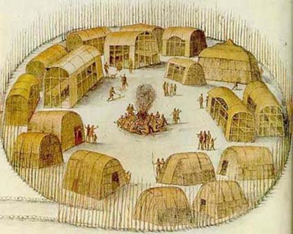
Secotan Village by John White
Tracking Ancient DNA
Tracking Ancient DNA
An Interview with Bennett Greenspan of Family Tree DNA Testing Company
"Ghost Ship in the Fog"
This blog contains links to other sites on the Internet. This does not constitute approval of these sites. They were deemed interesting at the time we viewed them. Websites do change over time so if any are no longer of value, inappropriate or otherwise unsuitable, please notify us. *Additionally clicking on Next Blog in the toolbar at the top of this page takes you COMPLETELY OFF this page. We have no control of the content of the sites you may encounter after you leave this site. You may encounter objectionable material. This is out of our control. *
Lost Colony Drama
Television News Lost Colony Interview
Sun rising off the coast of Roanoke Island
Indian Villages

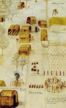
John White Drawing of Pomeiooc
