Waterside Theatre Presenting These Entertaining Productions in 2010!
Virginia Dare Faire

This blog is © History Chasers
Click here to view all recent Lost Colony Research Group Blog posts
Waterside Theatre Presenting These Entertaining Productions in 2010!
Virginia Dare Faire
by Janet Crain
By all accounts Fort St. George, in present day Maine, should have succeeded. It was well financed and expertly planned.Established in 1607, it was intended to contain thick battlements, great crenellated gates, several mansions, a church, fifty other buildings, and a walled garden. A dozen cannon pointed toward the sea.
The fort was the brainchild of Sir John Popham, one of the most important and powerful men in England during Queen Elizabeth I's reign. He intended to solve one of England's biggest problem; a huge surplus population of destitute people with no means of support.
Convinced this situation was the primary cause of crime, Sir Popham wanted to sweep up the "dregs" of England and put them to work in the new world earning their keep.
At this time tinkers, vagabonds, gypsies, and wandering artists and actors were considered as prime candidates for this "benefit" to be bestowed upon them, along with felons, and prostitutes, pickpockets and highway men.
Fort St. George was built entirely with enforced transported labor. Later called indentured servitude, this system is American history's best kept secret. Later the European servants were joined by Africans and Indians. There was no difference in their treatment or status. Some had kind masters, many had harsh cruel masters. Only after Bacon's rebellion would the races be treated differently.
Even Thomas Jefferson was deluded when he wrote that only about 2,000 convicts were transported to America and they were mostly sickly men who soon died and left no descendants. In truth there many many more. Add to them those transported for trivial reasons, those sold into servitude by captors, masters or themselves and the unknown number dumped here by Cromwell and it's clear that most of us have these people numbered among our ancestors. Rather than deny them, we should celebrate their will to survive and honor them.
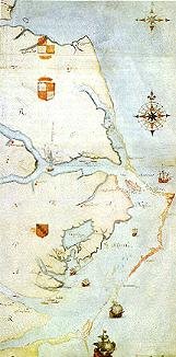
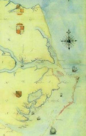
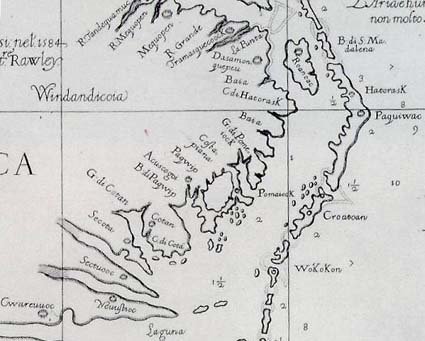
Everything we learn about Jamestown and Fort St. George sheds light on the First Colony at Roanoke. This map is therefore of great interest. The men who planned these settlements, sailed the ships, explored our shores and inland areas were contemporaries. Back in England they knew each other well. They may have schemed and plotted against each other in the Elizabethan Court and later that of King James, but they were cut from the same cloth. And their motives were similar. It was not altruism that brought about this new nation.

Fort St. George, named for the patron saint of England, was built in 1607 by Popham Colony near Sabino Head, ten miles/15 kilometres south of what is now Bath, Maine, United States. It was abandoned after a year of occupation and is now an archaeological site. [1] [2]
John Hunt, a draughtsman present at the fort when it was built, drew a map showing[3] a star-shaped fort including ditches and ramparts, a storehouse, a chapel and more than fifteen structures. It contained nine guns that ranged in size from demi-culverin to falcon. As a result of espionage by the Spanish ambassador to London, Pedro de Zuniga, the map was passed to King Philip III of Spain, in 1608.[4] It was found in 1888 in a Spanish archive. [5] It is unique as the only plan of an initial English settlement in the Americas known to survive.
Related:
http://historical-melungeons.blogspot.com/2008/07/on-misfortune-of-indentured-servants.html
Cont. here:
Charles Hardy, president of the Outer Banks Community Foundation Board of Directors, previews The Lost Colony's new education site with John Buford, public relations and marketing director for The Lost Colony. The education website was created with funding provided by the foundation and is being created to serve as a educational tool for both students and teachers.The Outer Banks Community Foundation has awarded a $6,200 grant to the Roanoke Island Historical Association to support the construction and development of new pages to the education component of their website, www.thelostcolony.org.
The Roanoke Island Historical Association, an educational and historical non-profit organization, preserves the nation's cultural heritage through the production of the acclaimed drama, The Lost Colony. North Carolina history school books for the 4th and 8th grade levels include the study of both Sir Walter Raleigh's colonies and The Lost Colony production. As such, the Association has diligently worked with North Carolina school systems in developing programs to meet these education needs including school visits, backstage tours for school groups, study guides for teachers and students, and most recently, a special matinee performance for school children in the area's school districts that was attended by 1,400 students. The Association's new educational web pages augments the educational elements of these programs.

Day 5 - August 20 – Thursday
by Roberta Estes
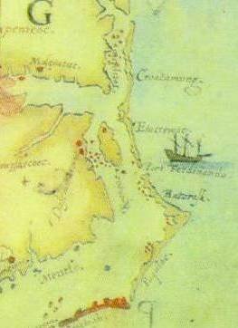
I’ve been looking forward to today for 2 years now. Anne and I are going to Hatteras Island which is where Croatoan is located. Croatoan, if you recall, is the location that the Lost Colony carved on the post and the tree at Fort Raleigh as a message to John White telling him where the colony had removed to. He found it on his return voyage in 1590 and was thrilled that the colonists were among the friendly Indians headed by Manteo, their friend who had gone with them to England twice.
John White was also greatly relieved by what he did not find; no cross. Their agreement was that if the colonists left under duress or in distress, they would carve not only their location, but a cross. There were no crosses anyplace, and the houses had been disassembled and removed, not ransacked, so their move was obviously orderly and planned, not hurried.
John White wanted to visit Hatteras Island, they called Croatoan, but a violent storm interfered with is plans, drowned some of the men, and nearly sank their ships. They had to abandon those plan and return to England. So close, yet so far away.
Anne and I retraced that journey today. After leaving Roanoke Island, we crossed the bouncing bridge and turned onto NC 12. NC 12 is the ribbon highway that runs the length of Hatteras land for more than 50 miles. The island starts out running North to South, but does a dog-leg turn in about 45 miles at Buxton and then runs East to West. The North to South portion is generally not inhabitable. Now of course there are a couple of tiny villages with a few hearty souls who must not need insurance who have built right on the sand dunes on the ocean on a tiny spit of land not more than an eighth of a mile wide in some locations. But these locations do not support any agriculture because there is only sand and no dirt. In fact, these areas are quite picturesque. The park service has erected sand fences in some areas to attempt to reduce erosion and the sand drifts around the fences. However, the road has been washed out many times and new inlets through the island are often created during hurricanes and other bad storms, letting us know indeed how fragile those islands truly are.
In some locations, maritime forest exists on the islands. While this is different than mainland forests, it’s still beautiful and often blocks the view of the ocean making the distance to the ocean from the road seem far greater than it is.
This site has beautiful photos of the Outer Banks. Take a look and share the unique charm and the stark beauty. You can see Maritime forest in many of these photos.
http://www.duke.edu/~jspippen/vistas/outerbanks.htm
We stopped in Buxton and visited Scott Dawson at the Croatoan Inn. Scott and his wife own the inn and Scott has a beautiful collection of Native artifacts found on the beaches and elsewhere on Hatteras Island.
http://www.thecroatoaninn.com/
Scott is a wealth of information about the history of Hatteras Island. He is passionate about the colonists who he believes assimilated with the Indians. Indeed, they told us they were going to Croatoan and Hatteras Island is Croatoan. This part of Hatteras Island is the first location between Roanoke and the end of Hatteras Island that can sustain a population and grown food, and the Indians have inhabited that island at least seasonally for thousands of years.
Scott has done a great deal of research on the topic and his book “Croatoan, Birth Place of America” is now in its second printing.
http://www.buybooksontheweb.com/product.aspx?ISBN=0-7414-5469-6
We had read the book and wanted to see the area for ourselves as well as some of the landmarks Scott discussed in his book. Even though he couldn’t leave the hotel and go with us, he was kind enough to tell us how to locate several items, including the Cora tree.
The Cora Tree and the coffins are in very close proximity. The coffins were, unfortunately, reburied many years ago, right after they were accidentally excavated by a drag line operator before anyone realized the significance of what he had stumbled upon. However, we do know the general area where the canal digging as going on and the Cora tree is in the same vicinity.
The Cora tree is quite interesting, although maddeningly inconclusive just like so much else about the Lost Colony. Recalling that the colonists were to carve the location of where they were moving on a tree or post, this tree is over 1000 years old, so even in 1600 or so it would have been remarkable. At that time it was already 600 years old, a substantial tree.
Did the colonists carve a second message to their hoped-for rescuers after they moved to Croatoan? Were they trying to tell John White where they went if they moved a second time? Is Cora similar to Coree? The locals tell the story that
Cora was a witch who was hung in the tree and lightening carved the name Cora in the bark.
From there Anne and I drove around the area where we knew the coffins to have been, and revisited the sites of earlier archaeological digs, although there have been very few on Hatteras Island, with most digs being focused on Fort Raleigh and that area. Earlier digs on Hatteras (Croatoan) were very successful, unearthing a gunlock and the Kendall family signet ring among other English items. In the 1930s, a man found a sword in that area as well. Again, while confirming the presence of the English on the island, it doesn’t confirm that the colonists themselves were there and that that they weren’t later artifacts. Kendal was in the 1585-86 military expedition, but not in the 1587 group, so we may be finding artifacts from the military expedition, not the colonists themselves.
How I would love to test the DNA of the skeletal remains in those caskets. It could potentially tell us a great deal about what happened between 1587 when the colonists moved to Croatoan and the next “sighting” we have directly of their descendants which is in 1701 when John Lawson visits the Hatteras Indians and reports that they have grey eyes and some have light hair as well. The Hatteras told Lawson that their ancestors were white people and talked in books. The Hatteras also tell of a ghost boat which appears on misty nights and is Raleigh’s boat which has come for them.
How many misty and foggy nights indeed did the colonists spend watching for any sign through the mists of their rescuers? Did they every give up waiting? At some point, had they assimilated so well into the Native culture that they no longer wanted to be rescued? Did they in fact survive to have descendants in the present generation, or did they survive only long enough to be annihilated by disease or warfare with other warring nations and the white settlers as well during the long and bloody Tuscarora War and preceding events?
After some artifact hunting on the beach, from which we turned up empty handed, we ate at a place that passes for fast food. Let’s just suffice it to say it took as long to get a salad, burger and piece of pizza as it would have taken to wait on a table at the nicer restaurant (20 minutes) and have ordered and eaten a dinner. Let’s just say that calling the food mediocre would be doing it a favor. That restaurant is definitely on my “never again” list.
Our drive home was in the dark, and it’s amazing just how dark dark is on the island. Of course, there are no street lights and in the areas with no habitation, there is also no ambient light. The mainland is often out of sight and if you look eastward of course there is just ocean and more ocean. Anne and I watched the ocean and wondered if Hurricaine Bill will cause severe rains and flooding, but this evening, and for a couple of more evenings, Hurricane Bill isn’t a problem. But one this is for sure on the Outer Banks, if this hurricane misses you, there’s always another one waiting in the wings. The surfers count on that.
We arrived home under the poplar tree quite late, for the last time for me. I packed and got my car ready to load in the morning. I slept restlessly trying to decide whether to risk the traffic by going north by Washington DC or take the longer route westward and up 77. By 4:30 AM or so, I had come up with a compromise plan which took me north to Richmond they west on 64 which should keep me out of traffic and rain with little backtracking. My GPS this morning was not happy with my decision. How I just love having a bossy woman in my car. I swear she sounds more disgusted with every direction of hers that I don’t follow. She gets confused sometimes and got herself all bolluxed up near Richmond, nearly sending me to Washington DC in spite of what I told her to do.
This morning when I woke up, I looked out the bedroom window to see condensation running down the window….and it wasn’t raining. It was just that humid. No need to dry your hair here, because it’s going to be wet again in 2.7 minutes. And makeup – only waterproof. But none for me thank you…..I got over that about the same time I got over staying up late.
As I was loading my car for my final trip across the bouncing bridge, Turkey Lurkey ran up and offered some parting advice….I’m not sure I understood her correctly, but I think it was something about not celebrating Thanksgiving this year.
Read all posts in the Trip to Roanoke series:

Wednesday – Day 4 - August 19th
After staying up way too late last night at the cast party, we slept a little late this morning. I can’t remember the last time I as up till 3AM for a positive reason! However, even with nothing stronger than water to drink, I could certainly feel the late night this morning. How did I ever think this was fun when I was younger?
By noon, Anne and I were absorbed in acid free boxes chocked full of surprises at the
I made another important discovery today. There are no quilt shops on the Outer Banks. Now you’d think with nearly 100 miles of ribbon-like highway and thousands of tourists on that one highway, at least some of them would be quilters and would want to take home more than a shirt, a sunburn and some sand in their shoes for souvenirs. Apparently not, because there not only aren’t any quilt shops, there aren’t even any plain old vanilla fabric stores. Hello, how can you live without JoAnne Fabrics? The closest store is at the far northern end of the
When visiting the Outer Banks, you have to stop at Kitty Hawk Kites. Kitty Hawk Kites is quintessential Outer Banks. Where is Kitty Hawk Kites? Everyplace. There are many of the stores and yes, they have just stunningly beautiful kites. One thing the Outer Banks always has is wind…and it‘s so hot there that you’ll be exceedingly grateful for that wind, let me tell you. So it’s also a kite flyer’s dream and even if you can’t fly a kite, you can there. There’s no way you can’t fly a kite on the shore line, so indeed, go fly a kite.

We ate at the Beach Road Grill, a long-time local favorite and had their house-special steamed and spiced shrimp, served hot with drawn butter and cocktail sauce, along with black beans and rice. Their black beans and rice are served half on one side of the dish and half on the other (rice on one end and beans on the other) with hot salsa across both halves. Nothing like this up north, I guarantee you. Lovely waitress as well. Southern hospitality at its best. The harmonica player was going to start shortly, but we were just too tired to stay up late again, so we left amidst a beautiful sunset, crossed the bouncing bridge, watched the lightening over the sound above Manteo and went home under the poplar tree and called it a night.


Baum bridge over Roanoke Sound
Day 1 Aug 16 2009 Sunday
By Roberta Estes
I had been looking forward to arriving on the Outer Banks for the Virginia Dare Faire for weeks now. My car looked more like I was moving than going on a working vacation. I felt like a modern day Beverly Hillbilly. Anne has moved into her summer home in Wanchese and I’m contributing things from my mother’s home. It’s only fitting it seems, as Anne and I are on a mission together and I’ll be staying with her from time to time as we research and search for the Colonists.
So the back of my Jeep has the seats laid flat, a table with the legs removed, several boxed with miscellaneous kitchen paraphernalia that each has a memory for me, and of course really important things like books relating to our search, several inches of paper relating to our research plan, and, oh yes, trivial necessities like clothes. Of course, I can’t go anyplace without my electronic tether, or lifeline, whatever the days perspective…..my computer and cell phone. I’d be lost without either.
Last night after arriving, I answered e-mails and sent clients information and kept up with the world outside of Wanchese. But back to the Outer Banks.
I drove from Michigan via Pennsylvania, Maryland and Virginia this time, as opposed to the more westerly route down 77. I have driven that before to Washington DC, but never beyond. The area through Pennsylvania and Maryland is connected to my early German families and I always think that I need to do more research on them and stop and see where they lived. But that trip will have to wait for another time.
Given that I was in the area of our nation’s capital on a weekend, I didn’t mind risking the Capital Beltway, but I’d never do it on a weekday. That’s analogous to taking your tourist type life in your hands. The 150 miles and supposed two hours I would have saved taking this route would have been likely to evaporate in a single traffic jam.
But on Sunday I whizzed around Washington and noticed that building construction continues there. They apparently aren’t experiencing the same level of recession we are suffering under in Michigan where there is no building and many half-constructed buildings have been abandoned and sold at auction. I whispered my perennial prayer for wisdom and guidance for those in power as I drove by….although my prayers perennially seem to go unanswered in regard to politicians.
I stayed in either Thornburg or Woodford. It’s a schizophrenic place. The Google map and the Holiday Inn website say Thornburg, but my GPS doesn’t know Thornburg Virginia exists, so I called the Holiday Inn and they said “oh yea, type in Woodford. Ok, so Woodford it was. And Google had the location the wrong expressway too, but details….who cares. At least my gps could find it after I typed it the second city. Maybe it’s like a maiden name and a married name for women…..
The free internet was awful, the room had once been a smoking room (do they think we can’t smell), but today the entire property is nonsmoking, and I managed to leave have of the cheesekeeper I was using to hold watermelon in my cooler. Rats. I always take a last look around the room too…..but I missed it somehow and I’m sure that the cleaning staff took one look at that and said “oh well” and into the trash it went. One more of Mother’s things I don’t have to figure out what to do with I guess….but that wasn’t what I had in mind.
Next I passed Richmond and Newport News which began to look like a coastal area with boats, ships really, and cranes and port type of paraphernalia towering over the horizon. Before arriving at Newport News, the area looked strikingly colonial, not nautical. I’m always amazed when traveling in the eastern Virginia area, even near large cities, how wooded the landscape remains. The expressways look more like parkways and not like the sprawling cement ribbons that clear everything to desolation with half a mile in all directions that we have in the Midwest.
South of Newport News, I encountered a surprise. My GPS indicated that I was going to cross an expanse of water, which would be my first real glimpse of the Atlantic on this trip. As I approached, I noticed signs for a tunnel. Hmmmm…..now tunnels are not my favorite things, but they are a fact of a driving/traveling lifestyle, and once you’re in route they are impossible to avoid, so tunnel it was. This tunnel was unusual though in that it only went half way across the channel or estuary and rose in the middle of the river (whatever you call these wide entrances into the ocean that empties fresh water into the ocean but is also tidal in nature) and became a bridge for the second two thirds or so of the crossing. How so they keep the tunnel from flooding? Amazing. However, I noticed the large “doors” on the end as I entered which made me a little nervous and could be the makings of a horror movie or a nightmare, but I chose not to think about those. They are probably closed during hurricanes.
Speaking of hurricanes, when I left Michigan, there had been none yet this year. Last night there were 3, one which arrived in Florida already and is weakening, one which is heading for the Caribbean, and one, Bill, who is going northwest of the Caribbean, may become a level 3 or 4 and is likely to strike the mainland by or on Friday. Now of course, this area is prime hurricane alley, much to the chagrin of Sir Walter Raleigh’s military colonists. Sir Francis Drake lost several ships in his visit in August of 1586 on these Outer Banks and he ended up rescuing the military colonists instead of resupplying them….but I digress.
As I approached the Virginia/North Carolina border yesterday, 64 transitioned from an expressway to a non-limited access 4 lane road. This is more than a technical transition and the introduction of stop lights. It was a complete change in flavor from a sterile environment with beehives of activity called exits where travelers stop and never stay beyond the closest meal, bathroom and gas pump to an area where travels pass through, but also where people live. It became alive with businesses, and few if any chains. I saw a few Home Depots, but then again, everyone needs those types of stores and here probably more than most with the constant battle of the elements of wind, sand and sea.
Mostly I saw flavorful and colorful hometown restaurants, fruit stands that advertised “free bathrooms” and Burma shave type signs for upcoming businesses. Somehow we subtracted about 40 years and returned to a slower, sweeter time when travel was more of an adventure and less of a race. I wanted to stop at several gift shops, a pawn shop or two (who knows what jewels await in there) and those luscious looking fruits stands with fresh fruit and local crafts decorating the outside of the barns by the roads. Yes, they are all inviting and call out as you drive by.
Further south, the fields continued and the crops looked healthy. Whoever said that the colonists would have not been able to sustain themselves on these islands? Did they visit and take a look at the agriculture? Sand dunes replace trees and marsh replaced fields eventually. In some places condos hug the very edge of the marshy expanses, making me wonder if some of those condos might just tip over and sink. And of course, facing the sea, I wondered about how to protect them from the raging hurricanes and if they could even purchase insurance, but then again, not my worry, I’m just a visitor. Many of the condos and beach houses weren’t on the beach, and frankly, couldn’t even see the beach. They could just see the other houses that also couldn’t see the beach. Talking to Anne later, she mentioned that even the “unlucky” houses were quite expensive. I have to wonder why you’d spend that kind of money to not be beachfront. I guess I’m way too logical. For me it would be beachfront or nothing at all I guess. If I couldn’t afford beachfront, there would be no point in second string. However, I suspect most of these are rentals or timeshares, so perhaps the answer is that they are investments. If that’s the case, then many of these investments are for sale now. I noticed one street of waterfront units where every single unit had a for sale sign on the side. I guess even if Washington isn’t experiencing our recession, the Outer Banks is, if the amount of real estate for sale is any indication.
Crossing from Manteo to Wanchese is the bouncing bridge. I’ve never been on a bridge that literally makes your car bounce up and down like a large beach ball. Now my Jeep has heavy duty suspension (it’s trailer rated), and that makes it ride a little tighter and not so sloshy as the land yachts, but still, this was a huge bounce. I noticed the pickup truck in front of me was bouncing too and so was whatever was in the pickup bed. The contents of the bed were bouncing at a different pace so the truck “caught” the boxes. I guess the message here is to tie everything down if you have a truck and are crossing the bouncing bridge.
Now I think this is new-fangled speed control device and a pretty good one too because the speed limit was about all the faster you could drive and not bounce yourself to death and into another lane. Each section of the bridge every few feet declined where it connected to the next section and then raised midway a bit, causing the wave action of bouncing up and down.
Arriving at Anne’s house was a real treat. She lived on Old Wharf Road with is the old road around the island. The turn into her road is landmarked by a beautiful old white church. Turning into her place leads you back away from the little old road and her house is back under a very large poplar tree. The tree shades the whole house and you park under the front part. The ground everyplace here is sandy, even if grass manages to grow on top of the sand. A tame female turkey named Turkey Lurkey greeted me. She had to check me out to be sure I was Ok and that I was a female. Turkey Lurkey doesn’t like males for some reason. I passed inspection and she settled down and let Anne pet her after eating some bread scraps. Turkey Lurkey is smart, she can fly over the fence in and out of the pen. Her friends or rather, penmates, the chickens simply stand and squawk at that uppity turkey who has the audacity to stand outside the fence and look back at them like they are, well, birdbrains.
After getting settled in and looking longingly at Anne’s screened in front porch, making mental plans for later, we ventured out for dinner. Most of the businesses and restaurants are closed here on Sunday, another, return to times of the past for me, but we went to a local favorite, Sam & Omie’s, which has been here since 1937. http://www.samandomies.net/ Sam & Omie’s has legendary She Crab Soup. Now what exactly is a She Crab and why do they make soup out of it? Well, duh, it’s a female crab and the soup includes crab roe (that’s eggs). It’s made in a cream based chicken stock broth with a touch of sherry. It’s a specialty of the area, but for Anne, it’s just a special treat for visiting Sam & Omie’s. Anne says the She Crab soup just isn’t right anyplace else.
http://whatscookingamerica.net/History/Chowder/SheCrabSoup.htm
It was yummy, yummy and so was the crab cake I had for dinner. Fresh and you can actually taste the crab. I didn’t even notice any filling but there had to be because it did hold together in a patty. I love the coast for the fresh seafood.
Our next adventure was to the grocery store where a pack of vultures had descended. Our first clue was no carts. No carts? On a Sunday evening? Well, all those rental properties rent from Sunday to Saturday and the new crop of vacationers all arrive at the grocery….you guessed it….on Sunday evening. Thankfully, the grocery was relatively prepared for the descending vacationers and we got in and out relatively quickly with our supplies for lunches this upcoming week. On Tuesday, Anne and I are going to have a table at the Virginia Dare Faire on Tuesday and there isn’t any food service right there. Anne and I take coolers and food and ice cold water. It’s August in the Outer Banks and HOT and HUMID here. And of course we don’t want to leave the table because after all, we’re there to talk to visitors will hopefully come to visit and learn about the colonists.
In preparation for the Faire, we have prepared a “Most Wanted” list of surnames associated with the colonists. We prepared this list based on the colonists’ roster, of course, plus historical records in NC that indicate these surnames were found there early and are associated with Native American tribes in the area.
Hopefully, fate with be with us and some folks will visit the Faire, visit our table and will be interested enough to work with us on their genealogy and maybe, just maybe, will be the right person in their line to take a genealogy DNA test.
Here is our “most wanted” list. Do you have any of these surnames in your family from eastern early North Carolina?
Allen
Bennett
Berry
Barbour
Beasley
Blount
Brooks
Brown
Buck
Carawan
Carroon
Carrow
Chapman
Chavis
Chavous
Cheven
Coleman
Cooper
Dare
Elks
Gibbs
Gurganos
Harris
Hewett
Johnson
Jones
Locklear
Lowrey
Lucas
Martin
Pierce
Scott
Smith
Squires
Payne
If you can’t visit us in Manteo tomorrow at Fort Raleigh at the Waterside Theater, then visit our Lost Colony website.
http://www.rootsweb.ancestry.com/~molcgdrg/
We hope to see you soon!!!
Read all posts in the Trip to Roanoke series:
Necklace inspires more digs
|
 |
| Mayor of Bideford Cllr Andy Powell swabs the DNA of Barnstaple businessman Philip Milton (right) |
Time Team could not have picked a better site for its maiden voyage in the New World. Both the story of Britain's first attempt at American colonization and one of the oldest unsolved mysteries in American history, the location of the Lost Colony of Roanoke is truly one question that only archaeology can answer. But finding the Lost Colony is no small task. Over the last 400 years, the fragile footprint left by the vanished colonists has become even harder to find. In that time, the site has been host to all manner of disturbances, namely: various military garrisons, farmers, the Civil War, treasure hunters, enthusiastic re-constructionists, a movie set, thespians, erosion, dune formation, and finally, modern archaeologists. As a result, the site of the Lost Colony has remained hidden. Like the proverbial needle in a haystack, the traces of this short-lived and ephemeral settlement have continued to elude even the best of efforts.
The biggest break in this centuries-long search came in 1991, with the discovery of Thomas Hariot's science center. This discovery provided the first tangible link to the colonists on the island. It also firmly established that the modern fort reconstruction was not the site of the original colony. The visible ruins are now thought to date to a period long after the colonists' disappearance. Speculation of the colony's whereabouts had always been strategically linked with the fort's layout, and now archaeologists were free to look at the site with fresh eyes. Most still presume the settlement lies somewhere within the Fort Raleigh National Historic Site, buried under the forested sand dunes. Some speculate that the colony may be underwater or washing out to sea from an eroding beach. Others suspect it could be located on an entirely different part of Roanoke Island.
http://www.pbs.org/opb/timeteam/sites/ft_raleigh/why.php June 26, 2009 Looking for the events and activities coming up on the Outer Banks? Every Friday, Miss Kitty is going to bring you the happening events for the next week. Saturday on the Outer Banks: Kitty Hawk Kites Kiteboarding Competition will be taking place at the Kitty Hawk Kites Kiteboarding Center in Waves Village. Come see some of the best kiteboarders in the world. Free demonstrations and competitions will be held throughout the day. For more information, call 252-441-4124 or visit Kitty Hawk Kites. Enjoy a night of theater with The Lost Colony at Waterside Theater on Roanoke Island. The performance begins at 8 pm. After the show, enjoy a backstage tour of Waterside Theater. For tickets or more information, call 252-473-2127 or visit The Lost Colony. You could head on over to Jolly Rogerwhere Michelle Sanchez will be hosting the ‘Alan Ross Karaoke Roadshow’ from 9 pm to 1 am. The Jesse Chong Band will be rocking the house over at Outer Banks Brewing Station (yeah, that’s the restaurant between the silos on the bypass). Or go see Krunch playing at Kelly’s Restaurant and Tavern. Read about the rest of the week here: http://kittydunes.wordpress.com/2009/06/26/events-on-the-outer-banks-for-june-27-to-july-3/Photos: click here
Events on the Outer Banks for June 27 to July 3
© History Chasers
Click here to view all recent Searching for the Lost Colony DNA Blog posts
 Road trips have become a tradition of summer. Everyone has memories from childhood of piling into the family car and hitting the road. The trips can be long or short, jam-packed with stops or just a quick visit. The great thing about road trips is that the possibilities are endless.
Road Trip to North Carolina
~Heading back toward the mainland on Route 64 the hustle and bustle of the beach community begins to quiet and the small town of Manteo is another worthwhile pit stop. The town of Manteo was named after a member of the Croatan tribe and it's history, as well as the history of Roanoke Island, stretches far back. The 1584, English settlers established a foothold on the island. Due to lack of supplies, bad weather and tense relations with the native tribes the fort eventually failed. Three years later, another group of settlers arrived to try to make a more permanent colony. Among them was the Dare family. Two months after they arrived on Roanoke, they gave birth to the first English-speaking child in the New World. The patriarch of the group was forced to leave the burgeoning colony. When he arrived back in 1590 there was no sign of the the English settlers. Their whereabouts where never discovered and the mystery remains. The Lost Colony has been the subject of many theories over the centuries. The most popular one was that the Croatans came to the help of the starving colonists and brought them into their tribe. There were countless reports of American Indians with blue eyes and light complexions, convincing some they were the missing colonists.
Today you can spend the day exploring Fort Raleigh National Historic Site, where you can get the full story of the various attempts to colonize the island. Take a stroll through the beautiful Elizabethan Gardens with its vibrant colors and traditional layouts. The young and old alike will enjoy boarding the Elizabeth II, a replica of the small ship that the colonists traveled over on from England. You can even stay to take in a performance of The Lost Colony play in the wooden fort.
~The majority of the Outer Banks are connected by bridges spanning the breaks between islands. However, when you get to the southern tip of Hatteras it is time to hop on board the car ferry. When you disembark on the far side, the only place to go is south to the quiet village of Ocracoke. The easiest way to see Ocracoke is on foot. The Ocracoke Lighthouse was built in 1823 and stands 75 feet tall over the village. The stark white building is the second oldest lighthouse in the United States. Despite the peaceful atmosphere that Ocracoke gives off, in the early 1700s it was home to a famous sailor. Edward Teach, also known as Blackbeard, was one of the most feared pirates of his time. For years he sailed the oceans looting and plundering. Eventually, Blackbeard decided to retire before the authorities caught up with him. He took his riches and retired to Ocracoke but apparently retirement wasn't good enough. The Governor of Virginia overreached his authority and made it clear that he wanted Blackbeard gone. On November 11, 1718 the HMS Pearl arrived in the waters off of Ocracoke and did not leave until Teach was taken care of. The tales of pirates and tall lighthouses are common occurences throughout the islands of North Carolina.

Book signing, chance to be knighted
|
Bideford Mayor's DNA plan to prove Founding Fathers' theory
dave.tanner@archant.co.uk
17 June 2009
 |
| THE Mayor with a 300-year-old map of Bideford. |
The Lost Colony of Roanoke: A WebQuest for 3rd Grade Social Studies
This is a great resource for kids. This would make a wonderful Summer project.
http://oncampus.richmond.edu/academics/education/projects/webquests/roanoke/
© History Chasers
Click here to view all recent Searching for the Lost Colony DNA Blog posts
Thursday May 21, 2009
The Lost Colony's 72nd production season begins on May 29, 2009, following the final dress rehearsal Preview Night on May 28. Performances continue throughout the summer until August 20, 2009: Monday - Saturday at 8 p.m. ((no performances on July 4, 11, 18, August 8, 15). For four nights (June 3, 4, 5 and 6, 2009), valid Dare County residents are admitted free to The Lost Colony. On these nights, residents are asked to bring canned food items to be donated to area food pantries.
© History Chasers
Click here to view all recent Searching for the Lost Colony DNA Blog posts
American Indian Holocaust and Survival: A Population History Since 1492 by Russell Thornton (1987)
Virginian Robert Beverly wrote of his Countrymen:
In all the latter voyages they never su much as endeavored to come near the place where the first settlement was attempted at Cape Hatteras; neither had they any pity on those poor hundred and fifteen souls settled there in 1587 of whom there has never since been any account, no relief sent to them, nor so much as an enquiry made after them, whether they were dead or alive, till about 3 yars after this, when Chesapeak bay in Virginia was settled, which hitherto had never been seen by any English Man. So strong was the desire of riches and so eager the pursuit of a rich trade, that all concern for the lives of their fellow Christians, kindred, neighbours and country-men, weighed nothing in the comparison, thou an enquiry might have been easily made, when they were so near them. (Beverley, 1705: 24-25)
Note that he mentions them as "kindred".

"There is but one entrance by sea into this country, and that is at the mouth of a very goodly bay, 18 or 20 miles broad. The cape on the south is called Cape Henry, in honor of our most noble Prince. The land, white hilly sands like unto the Downs, and all along the shores rest plenty of pines and firs ... Within is a country that may have the prerogative over the most pleasant places known, for large and pleasant navigable rivers, heaven and earth never agreed better to frame a place for man's habitation..."- Captain John Smith, 1612 Smith's Journey

Our Mission....Is to gather as much data as possible to prove that at least some of the colonists did in fact survive as has been suggested by numerous historical accounts, possibly having assimilated into the indigenous tribes of the area or having been taken captive, or both. As the various tribes moved inland, the colonists would have moved with them. If the colonists were enslaved, they could have been sold or traded and not remained as a group, being scattered to various locations.
Our research group will be working to connect the genealogies with the historical records and genetic results from individuals who are likely candidates to be descendants of the Lost Colonists. We have assembled names of interest that are compiled from the Lost Colony settlers and also from the early families found in the areas where the colonists are believed to have settled. Early land transactions and grants reference individuals with many of these last names as Indians.
Possible candidates to be connected to the Lost Colony come from the following groups of individuals:
1. Those who have any of the surnames of interest and whose genealogy ends abruptly early in Eastern VA or NC.
2. Those who connect via any of these surnames to the British Isles.
3. Those whose family has an oral history of being connected to the Lost Colony.
4. Those with Native American heritage from Eastern or early NC or VA.
General Information: restes@comcast.net
Webmaster: nelda_percival@hotmail.com
I'm using Nelda's original artwork in this blog, this site is the foremost website for Lost Colony research.


