A Sketch of the Early History
of Southwestern Virginia
By Ralph M. Brown
It is with the idea of collecting in one place data to be found in a score and more of works that this paper has been prepared. The writer lays no claim to being an authority on the subject, but he has spent many hours consulting books, magazine articles, and maps that deal with Southwestern Virginia, and has striven to separate fact from fiction or hearsay when he wrote down his notes.
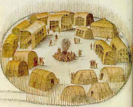
When Captain John Smith and his companions landed at Jamestown, in 1607, the Saponi and Tutelo tribes of Indians, belonging to the Monacan Confederacy of the Siouanº stock, probably had a few small villages in Southwestern Virginia. These tribes were the remnants of the Siouans,º that great stock which once inhabited Virginia "west of a line drawn through Richmond and Fredericksburg, up to the Blue Ridge, or about one-half the area of the State. In North Carolina, the Siouians were spread over the basins of the Roanoke, the Tar, the Cape Fear, the Yadkin, and the upper Catawba rivers, comprising more than two-thirds of the area of that state. In South Carolina, these Indians peopled nearly the whole central and eastern portion. In the three states the territory in question comprises an area of •about 70,000 square miles, formerly occupied by about forty different tribes".1
In prehistoric times, perhaps in the 16th century, the majority of the Siouians abandoned the country and gradually retreated across the mountains to the West, continuing their migration until they crossed the Mississippi River. "The most probable cause of this great exodus was the pressure from the north and from the south of hostile tribes of alien lineage, leaving to the weaker Siouian tribes no alternative but to flee or to remain and be crushed between the millstones."2
The Iroquoian tribe, the powerful Cherokee nation, succeeded the Siouians in the control of their former territory in Southwest Virginia. The Cherokees, although of Iroquoian stock, were hostile to the northern Iroquois and to the great Southern p502Iroquois tribe, the Tuskaroras, who lived along the Neuse River in North Carolina. The original territory of the Cherokees included "all of North Carolina and Virginia west of the Blue Ridge, as far north at least, according to their tradition, as the Peaks of Otter near the headwaters of the James River, together with the upper portion of South Carolina and the mountain section of Georgia and Tennessee".3 They were driven from the greater portion of their holdings, around 1672, by the northern Iroquois, and settled upon the Savannah River and in the territory south of the Tennessee River. The Cherokees apparently permitted the remnants of the Siouians to live undisturbed in Southwest Virginia, but the Siouians constantly attacked by the northern Iroquois, kept on moving their villages. "Up to 1670 the Monacan (Siouan) tribes had been but little disturbed by the whites, although there is evidence that the wars waged against them by the Iroquois were keeping them constantly shifting about. Their country had not been penetrated, except by a few traders who kept no journals, and only the names of the tribes living on the frontiers of Virginia were known to the whites. Chief among these were the Monacan proper having their village a short distance above (the present) Richmond."4 This settlement was identical with the "Mowhemenchouch" or "Massinacack" found by Newport's expedition, from Jamestown, in 1609. The English, settled on their border (at the falls of the James (Richmond) ), of course were constantly encroaching upon them, and they rapidly wasted away. The English, the Powhatans, and the Iroquois all waged war against them.
In May, 1670, John Lederer, a German traveler, under commission from the governor of Virginia, explored the country from the settlement at James falls (Richmond) southwestward through Virginia and North Carolina to a village of the Saura, then apparently located on a northern affluent of the Yadkin River, in North Carolina. On the third day, he passed through the Monacan village on the James only twenty miles above the falls. After traveling for days over a rough road, without meeting any Indians or sign of habitation, he arrived at "Sapon", a town of the Nahyssans, probably on the Otter River, southwest of Lynchburg, Virginia. The inhabitants of this village belonged to the Siouian stock, who were called "Tutelo" by the Iroquois. Three days of easy travel carried him •fifty miles southwest of the Siouian village of the Occaneechi, at the junction of the Roanoke and Dan rivers, near Clarksville, Virginia. This village was on a prehistoric path, which ran from Bermuda Hundred, on the James River, to Occaneechi. Thence it passed to the Catawba, Cherokee, p503and other tribes in southwestern North Carolina and northwestern South Carolina, and from the Catawba, via the Cungaree Post, to the present Augusta, Georgia. Its entire length was somewhat over 500 miles. Lederer then struck out to the Southwest, visiting a number of Siouian villages in what is now North Carolina, and afterwards returning to Apamatuck (across from Fort Henry (Petersburg) on the Appomattox River).
The next year (1671) an exploring expedition under Thomas Batts and Robert Fallam, with two Indian guides, left the Appomattox village (now Bermuda Hundred, Virginia), at the mouth of the Appomattox River to discover what lay beyond the mountains. "The three gentlemen bore a commission from Major-General (Abraham) Wood, obtained from Governor Berkeley of Virginia, for the finding out the ebbing and flowing of the Waters on the other side of the Mountains in order to the discoveryº of the South Sea."5
On the fourth day they reached the Sapony or Nahyssan villages, one of which Lederer had visited the year before, on the Otter River, southwest of Lynchburg. They pushed on to a Hanahaskie (Siouian) town; some twenty-five miles west by north, on an island in the Roanoke River. Following up the Roanoke River, they soon came in sight of the mountains (the Blue Ridge). The next day they arrived at the Totero (Tutelo) Indian town, in the vicinity of the present Salem, Virginia. From there they followed the imperial trail up the North Fork of the Roanoke River and crossed the divide somewhere north of Price's Mountain, thus probably passing the future Draper's Meadows on their way to the New River, which they struck, possibly at the mouth of Strouble's Creek, and went down the river a short distance beyond the Narrows at Peter's Mountain, to Union, West Virginia. Here they were compelled to turn back because their Indian guides were "impatient of a longer stay by reason it was like to be bad weather, and that it was so difficult to get provisions".6 They returned to Fort Henry (Petersburg) by the same route they had followed coming out. The journey took 13 days going, and 10 days returning. The distance travelled from the Appomattoc village (Bermuda Hundred) to Union, West Virginia, where they turned back, was •about three hundred and sixty miles, making the round trip approximately 720 miles.
This expedition was probably the first one to reach the New River, although "cropping out in all the literature of the Mississippi Valley exploration from the eighteenth century to the monographs of contemporary scholars, is the bare statement, p504now calmly presented as a fact, now contemptuously mentioned as a lie, that in the year 1654 or at various times in the decade following that year Abraham Wood (who commissioned the Batts and Fallam expedition) gained the banks of the Ohio, or of the Mississippi, or both. It can probably never be either proved or disproved with absolute certainty, but long and patient search has yielded the facts about to be recited, and only these . . . Dr. Daniel Coxe was the first to mention the episode. His account appears in a memorial to King William, presented to the Board of Trade November 16, 1699, and, in the younger Coxe's book 'Carolina'. Coxe states that at several times during the decade 1654‑1664 Wood discovered several branches of the great rivers Ohio and Meschabe (Mississippi). In confirmation, Coxe alleges that he was at one time in possession of a journal of a Mr. Needham, one of the agents Wood employed in his exploring expeditions. Now Wood's men did discover branches of the Ohio and Mississippi, in the years 1671‑74; and the Needham referred to was employed in the most brilliant of these discoveries (that of the Tennessee River, in 1673). Since Coxe states incorrectly both Wood's title and place of residence, it is most probable that his information about the date was also incorrect. It would seem that subsequent writers have simply followed Coxe, either at first or second hand . . . The whole tone of Fallam's journal and of Wood's letter regarding the explorations of 1673‑74, and especially Wood's references in that letter to the discoveries of Batts and Fallam, in 1671, make it reasonably certain that Wood had not been on the western waters at any prior time."7
Soon after 1701, the Siouians, constantly attacked by the northern Iroquois (the Cherokees did not disturb the Siouians), began to group together in a large tribe, first making a settlement, called "Sapona Town", a short distance east of the Roanoke River and about 15 miles westward from the present Windsor, in Bertie County, North Carolina, and finally, in 1711, locating near Fort Christanna, about the site of the Gholsonville, Brunswick County, Virginia, of to‑day. This by permission of Governor Spotswood. About 1740, having made peace with the northern Iroquois, the last of the Virginian Siouians, the remaining members of the Tutelo and Saponi tribes, went north, stopping for a time at the Indian village of Shamokin (Sunbury), Pennsylvania. In 1753, the Cayuga Indians, living near Ithaca, New York, formally adopted the Siouians, who then became part of the Six Nations — the Iroquois.
With the departure of the last of the tribes of the Siouians from Southwest Virginia, in 1711, the region was probably cleared p505 of all Indian settlements. The entire great valley was disputed Indian territory, both the Cherokees and Shawnees holding it as their hunting ground.
William and Mary Quarterly
2nd Ser., Vol. 17 No. 4 (Oct. 1937), pp501‑513
the text of which is in the public domain


