Pages

Saturday, July 31, 2010

Colonial-era shipwreck moved to Hatteras museum


This ship is believed to be the oldest wreck ever found on the North Carolina coast and was unidentified. If only these old boards could talk!

COROLLA, N.C.

After surviving perhaps 400 years in the sand and surf off the North Carolina coast, the 12-ton remains of a shipwreck are making their final port-of-call.

What could be the oldest wreck ever found on the North Carolina coast was loaded onto the back of a truck Monday for a 90-mile trip to the Graveyard of the Atlantic Museum in Hatteras.

Salvaged from the pounding surf in April, the wreck has rested under the shade of an oak tree near the Currituck Beach Lighthouse for the past three months.

But the massive beams have shrunk a little and cracked in the hot, dry weather. Experts plan to place the wreck on a concrete slab next to the museum and soak the 17-by- 37-foot remains in hopes of arresting the deterioration.

One possible preservative is a mixture of water and Elmer's wood glue, said David Moore, curator of nautical archaeology for the North Carolina Maritime Museum.

Cont.
http://hamptonroads.com/2010/07/what-may-be-ncs-oldest-shipwreck-be-moved?cid=ltst#rfq

This blog is © History Chasers
Click here to view all recent Lost Colony Research Group Blog posts Bookmark and Share

Tuesday, July 27, 2010

"A Kingdom Strange"

by Janet Crain
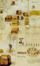
It is important to remember that this little band of would be settlers carried an enormous weigh on their backs. They were the forerunners of the English colonies that became the United States. Had they been discovered they would have been murdered by the Spanish as the French Huguenots were in Florida. Had John White not have made it back to Ireland and later made an ill fated trip to Roanoke nothing would be known of the colonists.

Fortunately we do know a great deal and after more than 400 years more is being discovered.

Rob Hardy: "A Kingdom Strange"


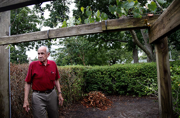
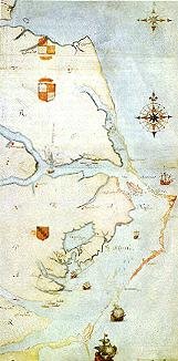
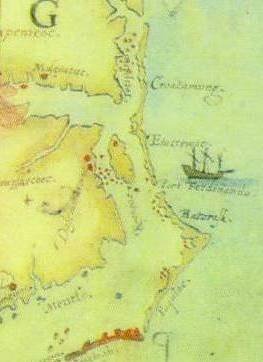
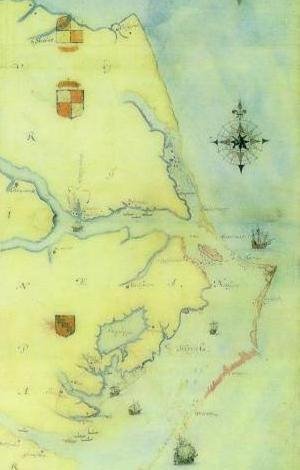
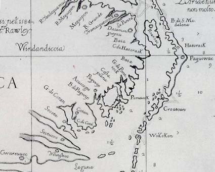
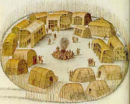
The Lost Colony of Roanoke was a failed initial effort of England to colonize America. It may have been a failure, but it continues to fascinate people; there is a famous outdoor stage production with music that attempts to dramatize the settlement at its site and a reconstructed fort.

The fascination isn't so much because of historic significance, but because the 117 settlers vanished without a trace. That is, almost without a trace. In "A Kingdom Strange: The Brief and Tragic History of the Lost Colony of Roanoke" (Basic Books), historian James Horn finds all the traces we can ever expect to turn up, and speculates on answers as close as we are going to get. That ought to make it an attractive volume for anyone who has heard of the colony's mysterious disappearance.

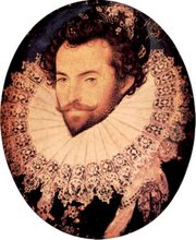
The larger attraction of the book, however, is to put the colony into historic context. The colony was an attempted blow by Britain against Spain, and what's more, it became lost at least partially because of the larger war between Britain and Spain. The hapless colonists, who if things had gone differently would have been celebrated as the Jamestown settlers are now, were instead the victims of a global war.

Horn imagines that Walter Raleigh, having moved to London in 1575, looked at a map of the New World and saw an extensive New France, and an even greater New Spain, but a "New England" was nowhere to be seen. During the reign of the father of Queen Elizabeth, Henry VIII, there was maritime trading with Europe and the Mediterranean, but little interest in America. Spain, however, had been particularly active in colonizing, and King Philip II had papal authority to convert the indigenous people to Catholicism. He deliberately took action to destroy the French settlements on the coasts of what are now South Carolina and Georgia because he did not want the Protestant heretics to take hold. Philip would have felt the same way about the attempts by Elizabeth to settle her Protestant countrymen into the area, although the British settlers, of course, would feel compelled to convert the heathens to their true church.

http://www.google.com/url?sa=X&q=http://www.cdispatch.com/lifestyles/article.asp%3Faid%3D7114&ct=ga&cad=:s7:f1:v0:i1:ld:e1:p1:t1280280831:&cd=sRGXXiFYHTQ&usg=AFQjCNGSD-JSleC7jChHTnYk8yF2UupGoA


This blog is © History Chasers
Click here to view all recent Searching for the Lost Colony DNA Blog posts Bookmark and Share

Monday, July 26, 2010

Was the Newly-Discovered NYC Ship Used to Transport Slaves?

This is an interesting account of a ship found at the base of the World Trade Center site in New York. Even more interesting is that this is not an anomaly. All of this area was filled in over the centuries. And part of the fill was old ships and shipwrecks. There is a world of information hidden here. And as the author says; "Ships were commerce, so there are ownership and insurance records, many still buried in archives in Holland and England. "
7-26-10

By Pearl Duncan

The author is completing a book about the variety of her ancestors’ DNA, ancestry and genealogy, and how each intersected with dramatic historical events.

People are willing to rewrite the story of the Wall Street-World Trade Center area in New York without knowing its history from a few centuries or even a few decades ago. But historical artifacts remind us where we’ve been.

The remains of a 32-foot section of a wooden ship, estimated to be about a third to a half of the hull, was discovered at the base of the World Trade Center site in New York. Archaeologists and scientists are collecting, testing and dating the wood of the ship’s hull. They are also testing a semicircular piece of metal arc, possibly part of the cooking galley, a shoe, spikes, anchor and other materials to identify the ship’ origins and use. They estimate that the ship dates back to the eighteenth century. They have determined that it was a cargo ship, from the size and shape of the hull. They have surmised that it was a sea-going vessel, since the layers of wooden planks are reinforced by layers of large, strong timbers. They figure from how it is situated in muddy ground that was once watery shore, and from maps of the harbor, that it was placed in the site as part the landfill that expanded the Lower Manhattan neighborhood in the late 1700s.

http://www.hnn.us/articles/129464.html


This blog is © History Chasers

Click here to view all recent Searching for the Lost Colony DNA Blog posts Bookmark and Share

Sunday, July 18, 2010

Wednesday, July 14, 2010

July 2010 Newsletter


July 9, 2010


Lots of work is going on behind the scenes. What did we ever do without e-mail and how did we collaborate on a project spanning two continents, three countries and many states, counties and provinces? Maybe the answer is that projects of this magnitude were handled differently, not at all, or proceeded much more slowly. Recently Andy and Baylus have been working together on the geography of the Outer Banks island chain. Come ride along with Baylus on their journey of discovery!!

Rediscovering The False Cape

By Baylus Brooks

Ever since Andy Powell emailed about the “false cape” in the area of Rodanthe on the Outer Banks it has been bugging me about the current water levels as compared with the water levels suspected in 1585 when John White made his map. It was much lower in 1585. By how much was the next question. What did the Outer Banks look like at the time that John White watercolored them? Why in the world did he paint such a prominent cape that no longer exists?

Here are the two versions of White’s map, compared in DeBry’s chosen orientation of West on top:

The point that I want to make here is that John White, without the benefit of a surveyor’s eye, drew a darned fine map! The "extra cape" (what I indignantly and once loudly called it) was not a figment of White’s imagination. It’s real. Andy Powell told us where to find it. So, I looked.

con't here (scroll down when you get there)


This blog is © History Chasers
Click here to view all recent Searching for the Lost Colony DNA Blog posts Bookmark and Share

Friday, July 9, 2010

FTDNA offering special prices for Y-DNA upgrades


Y-DNA Upgrade Sale at Family Tree DNA

Those of our readers who have already Y Chromosome tested at Family Tree DNA of Houston, TX will be interested to learn of this special temporary price on upgrades.

FTDNA is currently offering special prices for Y-DNA upgrades. The table below compares the regular surname group rates with the sale prices.

The promotion won't last long. Kits need to be ordered and paid for by midnight on July 19, 2010.

Click on the link below to go to the FTDNA web site. Then log in to your personal page and click on the special offers link in the left hand navigation bar.

Click for more info


This blog is © History Chasers

Click here to view all recent Searching for the Lost Colony DNA Blog posts
Bookmark and Share

Monday, July 5, 2010

Cherokee Communities of the South

Robert K. Thomas
Abstract
Cherokee Communities of the South was written by Mr. Thomas in the mid-70's. It includes a hand drawn map at the end and appears to be a result of some of Mr. Thomas' survey work in the southeastern United States during the summer of 1978 (?). It was submitted to the Consortium of American Indian Title IV Programs of Southeastern Michigan in 1979
Read the article here, click on "Download the Paper."

This blog is © History Chasers
Click here to view all recent Searching for the Lost Colony DNA Blog posts Bookmark and Share

Saturday, July 3, 2010

Herbicide Accident has Tragic Consequences

Ancient N.C. grape vine has near-death experience

Posted to:

Jack Wilson stands next to the power pole and damaged portion of the grapevine at his home in Manteo, N.C., on Wednesday, June 30, 2010. The "mother vine" as it's known, is believed to be the first cultivated vine in America and more than 400 years old. It was sprayed with herbicide while utility workers were trying to clear the nearby power pole. Wilson works to clear away the dead leaves every day (the pile is visible in the background) and hopes that the vine will survive. (Preston Gannawayt)

MANTEO

A large, old grape vine possibly growing here before the Lost Colony disappeared is on the mend after getting an accidental dose of a powerful herbicide.

But as experts continue to nurse the Mother Vine, including more pruning and fertilizing scheduled this week, a warning goes out to those who spray weeds in public places - be more cautious.

"From what I saw, this was just basically a lack of common sense," said Donald Hawkins, owner of Vineworks in Duplin County.


This blog is © History ChasersClick here to view all recent Searching for the Lost Colony DNA Blog posts Bookmark and Share