
Day 5 - August 20 – Thursday
by Roberta Estes
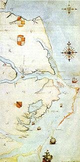
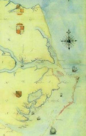
I’ve been looking forward to today for 2 years now. Anne and I are going to Hatteras Island which is where Croatoan is located. Croatoan, if you recall, is the location that the Lost Colony carved on the post and the tree at Fort Raleigh as a message to John White telling him where the colony had removed to. He found it on his return voyage in 1590 and was thrilled that the colonists were among the friendly Indians headed by Manteo, their friend who had gone with them to England twice.
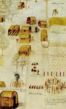
John White was also greatly relieved by what he did not find; no cross. Their agreement was that if the colonists left under duress or in distress, they would carve not only their location, but a cross. There were no crosses anyplace, and the houses had been disassembled and removed, not ransacked, so their move was obviously orderly and planned, not hurried.
John White wanted to visit Hatteras Island, they called Croatoan, but a violent storm interfered with is plans, drowned some of the men, and nearly sank their ships. They had to abandon those plan and return to England. So close, yet so far away.
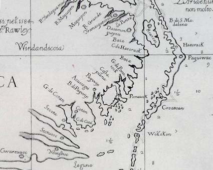
Anne and I retraced that journey today. After leaving Roanoke Island, we crossed the bouncing bridge and turned onto NC 12. NC 12 is the ribbon highway that runs the length of Hatteras land for more than 50 miles. The island starts out running North to South, but does a dog-leg turn in about 45 miles at Buxton and then runs East to West. The North to South portion is generally not inhabitable. Now of course there are a couple of tiny villages with a few hearty souls who must not need insurance who have built right on the sand dunes on the ocean on a tiny spit of land not more than an eighth of a mile wide in some locations. But these locations do not support any agriculture because there is only sand and no dirt. In fact, these areas are quite picturesque. The park service has erected sand fences in some areas to attempt to reduce erosion and the sand drifts around the fences. However, the road has been washed out many times and new inlets through the island are often created during hurricanes and other bad storms, letting us know indeed how fragile those islands truly are.
In some locations, maritime forest exists on the islands. While this is different than mainland forests, it’s still beautiful and often blocks the view of the ocean making the distance to the ocean from the road seem far greater than it is.
This site has beautiful photos of the Outer Banks. Take a look and share the unique charm and the stark beauty. You can see Maritime forest in many of these photos.
http://www.duke.edu/~jspippen/vistas/outerbanks.htm
We stopped in Buxton and visited Scott Dawson at the Croatoan Inn. Scott and his wife own the inn and Scott has a beautiful collection of Native artifacts found on the beaches and elsewhere on Hatteras Island.
http://www.thecroatoaninn.com/
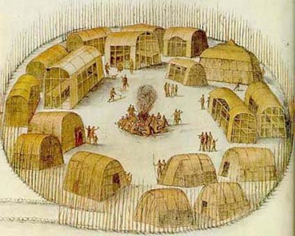
Scott is a wealth of information about the history of Hatteras Island. He is passionate about the colonists who he believes assimilated with the Indians. Indeed, they told us they were going to Croatoan and Hatteras Island is Croatoan. This part of Hatteras Island is the first location between Roanoke and the end of Hatteras Island that can sustain a population and grown food, and the Indians have inhabited that island at least seasonally for thousands of years.
Scott has done a great deal of research on the topic and his book “Croatoan, Birth Place of America” is now in its second printing.
http://www.buybooksontheweb.com/product.aspx?ISBN=0-7414-5469-6
We had read the book and wanted to see the area for ourselves as well as some of the landmarks Scott discussed in his book. Even though he couldn’t leave the hotel and go with us, he was kind enough to tell us how to locate several items, including the Cora tree.
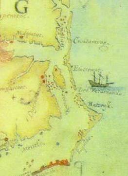
The Cora Tree and the coffins are in very close proximity. The coffins were, unfortunately, reburied many years ago, right after they were accidentally excavated by a drag line operator before anyone realized the significance of what he had stumbled upon. However, we do know the general area where the canal digging as going on and the Cora tree is in the same vicinity.
The Cora tree is quite interesting, although maddeningly inconclusive just like so much else about the Lost Colony. Recalling that the colonists were to carve the location of where they were moving on a tree or post, this tree is over 1000 years old, so even in 1600 or so it would have been remarkable. At that time it was already 600 years old, a substantial tree.
Did the colonists carve a second message to their hoped-for rescuers after they moved to Croatoan? Were they trying to tell John White where they went if they moved a second time? Is Cora similar to Coree? The locals tell the story that
Cora was a witch who was hung in the tree and lightening carved the name Cora in the bark.
From there Anne and I drove around the area where we knew the coffins to have been, and revisited the sites of earlier archaeological digs, although there have been very few on Hatteras Island, with most digs being focused on Fort Raleigh and that area. Earlier digs on Hatteras (Croatoan) were very successful, unearthing a gunlock and the Kendall family signet ring among other English items. In the 1930s, a man found a sword in that area as well. Again, while confirming the presence of the English on the island, it doesn’t confirm that the colonists themselves were there and that that they weren’t later artifacts. Kendal was in the 1585-86 military expedition, but not in the 1587 group, so we may be finding artifacts from the military expedition, not the colonists themselves.
How I would love to test the DNA of the skeletal remains in those caskets. It could potentially tell us a great deal about what happened between 1587 when the colonists moved to Croatoan and the next “sighting” we have directly of their descendants which is in 1701 when John Lawson visits the Hatteras Indians and reports that they have grey eyes and some have light hair as well. The Hatteras told Lawson that their ancestors were white people and talked in books. The Hatteras also tell of a ghost boat which appears on misty nights and is Raleigh’s boat which has come for them.
How many misty and foggy nights indeed did the colonists spend watching for any sign through the mists of their rescuers? Did they every give up waiting? At some point, had they assimilated so well into the Native culture that they no longer wanted to be rescued? Did they in fact survive to have descendants in the present generation, or did they survive only long enough to be annihilated by disease or warfare with other warring nations and the white settlers as well during the long and bloody Tuscarora War and preceding events?
After some artifact hunting on the beach, from which we turned up empty handed, we ate at a place that passes for fast food. Let’s just suffice it to say it took as long to get a salad, burger and piece of pizza as it would have taken to wait on a table at the nicer restaurant (20 minutes) and have ordered and eaten a dinner. Let’s just say that calling the food mediocre would be doing it a favor. That restaurant is definitely on my “never again” list.
Our drive home was in the dark, and it’s amazing just how dark dark is on the island. Of course, there are no street lights and in the areas with no habitation, there is also no ambient light. The mainland is often out of sight and if you look eastward of course there is just ocean and more ocean. Anne and I watched the ocean and wondered if Hurricaine Bill will cause severe rains and flooding, but this evening, and for a couple of more evenings, Hurricane Bill isn’t a problem. But one this is for sure on the Outer Banks, if this hurricane misses you, there’s always another one waiting in the wings. The surfers count on that.
We arrived home under the poplar tree quite late, for the last time for me. I packed and got my car ready to load in the morning. I slept restlessly trying to decide whether to risk the traffic by going north by Washington DC or take the longer route westward and up 77. By 4:30 AM or so, I had come up with a compromise plan which took me north to Richmond they west on 64 which should keep me out of traffic and rain with little backtracking. My GPS this morning was not happy with my decision. How I just love having a bossy woman in my car. I swear she sounds more disgusted with every direction of hers that I don’t follow. She gets confused sometimes and got herself all bolluxed up near Richmond, nearly sending me to Washington DC in spite of what I told her to do.
This morning when I woke up, I looked out the bedroom window to see condensation running down the window….and it wasn’t raining. It was just that humid. No need to dry your hair here, because it’s going to be wet again in 2.7 minutes. And makeup – only waterproof. But none for me thank you…..I got over that about the same time I got over staying up late.
As I was loading my car for my final trip across the bouncing bridge, Turkey Lurkey ran up and offered some parting advice….I’m not sure I understood her correctly, but I think it was something about not celebrating Thanksgiving this year.
Read all posts in the Trip to Roanoke series:
© History Chasers
Click here to view all recent Searching for the Lost Colony DNA Blog posts


